Where Is the Farthest Visible Point of Mt. Fuji? Analysis Using Elevation Data!
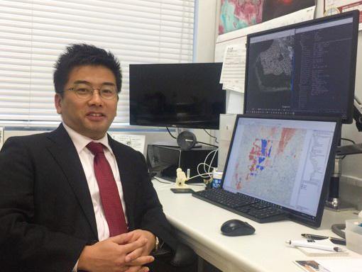
Have you ever wondered, “where is the farthest visible point of Mt. Fuji?”, meaning which areas of Japan can view Mt. Fuji. This time, we Sorabatake members asked Mr. Nagai, assistant professor of Waseda University who wrote the Google Earth Engine article for us before, if it is able to search it using satellite data.
Those who live around Kanto region may have seen Mt. Fuji in the distance on a fine winter day. Some people might have thought,
“Where is the farthest visible point of Mt. Fuji?”
If we check on the elevation data throughout Japan, it might be possible to find out the area which Mt. Fuji is visible.
However, we do not have any idea how we can visualize the range which Mt. Fuji is visible.
This time, we Sorabatake members asked Mr. Nagai, assistant professor of Waseda University who wrote the Google Earth Engine article for us before, if we can find the answer to the question using satellite data.
Sorabatake: Mr. Nagai, is it possible to search the area which we can see Mt. Fuji using satellite data?
Mr. Nagai: Yes, I think we can grasp the area if we use the altitude distribution data made from satellite observation.
Sorabatake: That’s what I thought! We want to know how wide the area we can see Mt. Fuji is.
Mr. Nagai: First of all, Mt. Fuji being sighted at wide area of Japan means the area sighted from the summit of Mt. Fuji is as wide as that. In fact, grasping the “visible area from the summit of Mt. Fuji” is very important.
Sorabatake: What do you mean by “important”?
Mr. Nagai: As a lesson we learned from Isewan Typhoon which gave a serious damage to the Tokai region in 1959, it once became an urgent business to grasp the track of typhoon heading towards Japan from Pacific Ocean. It was an important issue to decide where to set up the weather radar.
Finally, Mt. Fuji was chosen as the spot for it can observe the sky without getting interrupted by geographical features or obstacles. In addition, because the Earth is round, the higher the elevation is, wider the range of view grows.
Sorabatake: That means fairly wide range of sky could be observed from the top of Mt. Fuji. Now, I am more interested in finding the farthest visible point of Mt. Fuji! Is there a possibility that other mountains might get in the way?
Mr. Nagai: Yes, and it is very interesting question for me, too. Let’s analyse the farthest visible point from Mt. Fuji using the terrain data observed by satellite.
1.To Search for the Area That Mt. Fuji Is Visible Using Satellite Data
Sorabatake: How should we search the area which we can see Mt. Fuji?
Mr. Nagai: I will explain below;
●Retrieve the areas which are both “nearby Mt. Fuji” and “located in elevation higher than 3000 meters” using ALOS Global Digital Surface Model “AW3D30 (ALOS World 3D-30m)”
●Set approximately hundred representative points on 300 meters mesh.
●Find one point from Japanese field of “AW3D30”, and color the areas using the function of “Visibility” from Geographic Information System (ArGIS).
●Complement small defects by applying 100 meters buffer to the previous result.
※ It takes about 6 hours in applying the same process throughout entire Japanese field using 30 meters resolution DSM.
Sorabatake: Anyways, what is AW3D30?
Mr. Nagai: Terrain data without removing forests and artifacts is called Digital Surface Model (DSM). AW3D30 is a dataset made of images observed from 2006 to 2011 by stereoscopic sensor (PRISM) on Advanced Land Observing Satellite called “Daichi” (ALOS), processed into 5 meters horizontal resolution DSM with technology of stereoscopic, and connected within 30 meters mesh.
Sorabatake: I see. By using the dataset to find the area which can see the summit of Mt. Fuji and coloring them, the areas where Mt. Fuji is visible outstands clearly.
Mr.Nagai: That’s right. Now, let’s look for its visibility and invisibility in each regions.
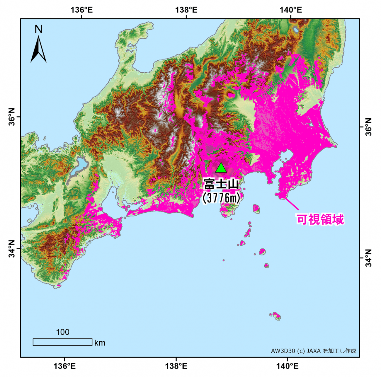
富士山:Mt. Fuji
可視領域:visible area
2.The Areas Which Mt. Fuji Is Visible
Firstly, the remote islands which could see Mt. Fuji were Hachijo-jima and nearby islands located north of Hachijo-jima.
Remote islands gets strongly influenced by the roundness of the Earth. As for the islands located in the south of Hachijo-jima, Mt. Fuji gets hidden below the horizon.
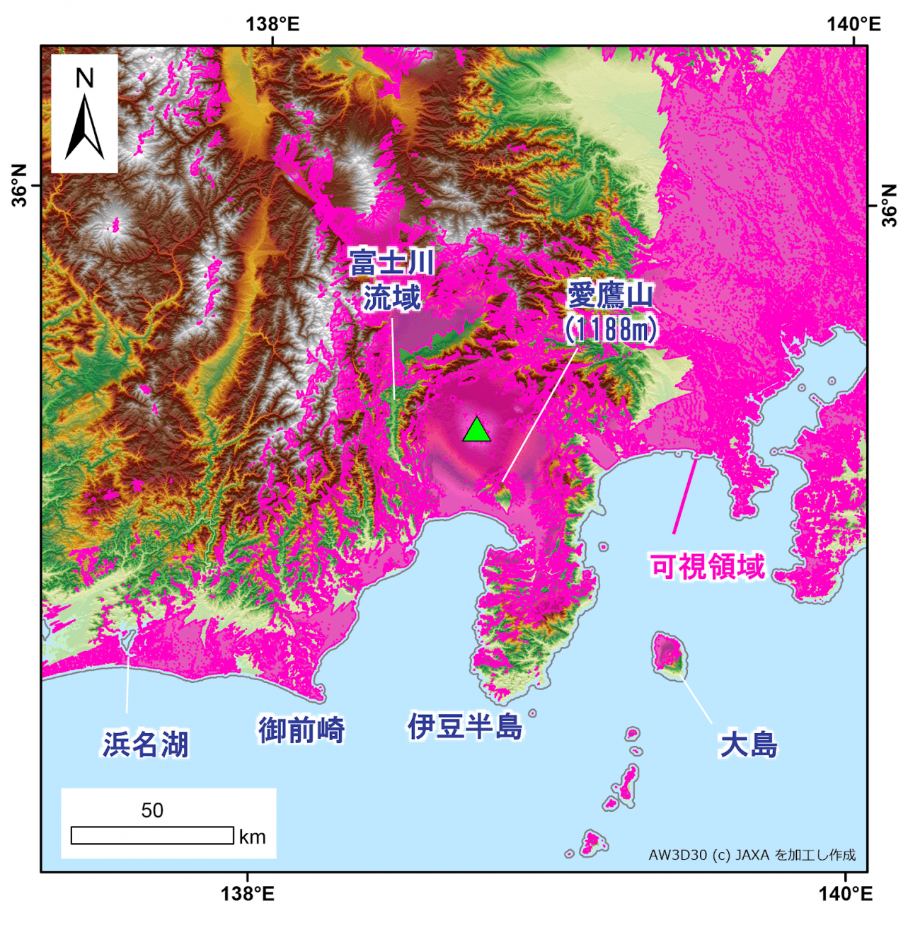
富士川流域:Fujikawa basin
愛鷹山:Mt. Ashitaka
浜名湖:Hamanako
御前崎:Omaezaki
伊豆半島:Izu Peninsula
大島:Izu Oshima
可視領域:visible area
There are not so much elevation difference in the remote islands, so it is able to have a distant view in all directions. However, in Izu Oshima with Mt. Mihara, only the area closer to the Honshu is able to enjoy the sight of Mt. Fuji due to the effect of the geographical feature.
When focusing on Honshu, it can be said that Mt. Fuji can be seen in fairly wide area. (see image #2)
Like Miho-no-Matsubara designated as a World Heritage Site, the areas on the Pacific side of Shizuoka Prefecture such as Omaezaki and Hamamatsu could be said to have good condition in viewing Mt. Fuji.
Then, where are the nearby areas that cannot see Mt. Fuji?
As shown in the image above, there are relatively many areas which cannot see Mt. Fuji in Izu Peninsula. Its complex terrain may be the cause of this invisibility.
There is also an invisible area near the southern foot of Mt. Fuji. As for this area, Mt. Ashitaka (1188 meters) blocks the figure of Mt. Fuji although it is located nearby.
Moreover, there is a blank space in the northern and southern area of Fujikawa basin. Its terrain with slightly deep valley may be the cause of this invisibility.
Like this, there are areas which cannot see Mt. Fuji due to its undulating terrain. I think it is very interesting.
3.The Areas Which Mt. Fuji Is Visible
Mt. Fuji can be seen from the greater part of Kanto Plain. However, as for the map shown below, it is likely that the interruptions of the high buildings and microphotography are not reflected, for small roughness are removed in order to make the map easier to see.
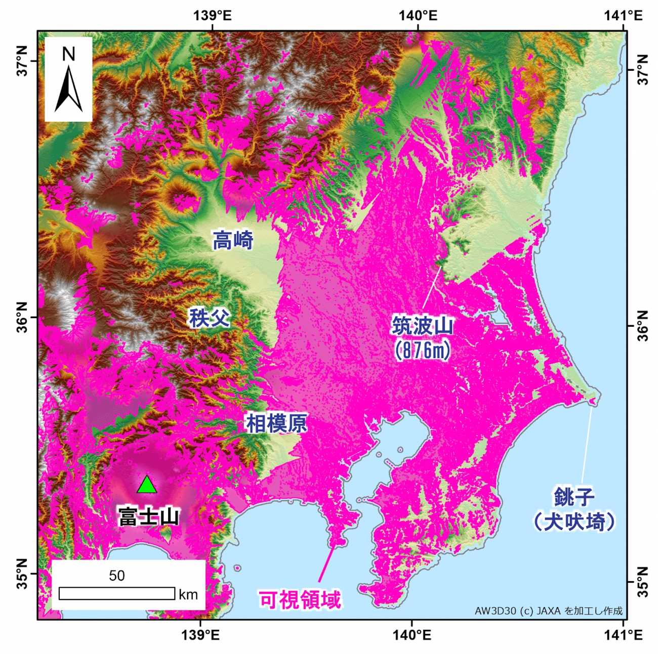
高崎:Takasaki
秩父:Chichibu
筑波山(876m):Mt. Tsukuba(876m)
相模原:Sagamihara
銚子(犬吠埼):Choshi(Cape Inubo)
富士山:Mt. Fuji
可視領域:visible area
When focusing on Ibaraki Prefecture, Mt. Fuji cannot be seen from the big part of the area north to the Lake Kasumigaura. There is Mt. Tsukuba (876 meters) between this area and Mt. Fuji, which may be the cause of this invisibility. Although Mt. Tsukuba is relatively low, mountain below 1000 meters can be a great influence when located in the distance.
Mt. Fuji can be seen from the Choshi, easternmost of Chiba Prefecture. There is Kujukuri Beach located in the south, which also seems to be the visible area of Mt. Fuji. This shows that Boso Peninsula is located in not so much high elevation, resulting in wide field of vision, not getting interfered by its terrain.
On the other hand, Mt. Fuji cannot be seen from the greater part of Takasaki in Gunma Prefecture and Chichibu area in Saitama Prefecture, located in the north of Mt. Fuji.
The same thing can be said with Sagamihara area in the Kanagawa Prefecture, located in the south of the area mentioned above.
Although those areas are nearer to Mt. Fuji compared to Ibaraki Prefecture and Chiba Prefecture, the mountain regions with elevation 1600 meters high seems to blocks the figure of Mt. Fuji.
4.The Areas Which Mt. Fuji Is Visible
How about the visible areas of Mt. Fuji in the mountain region of Chubu Region?
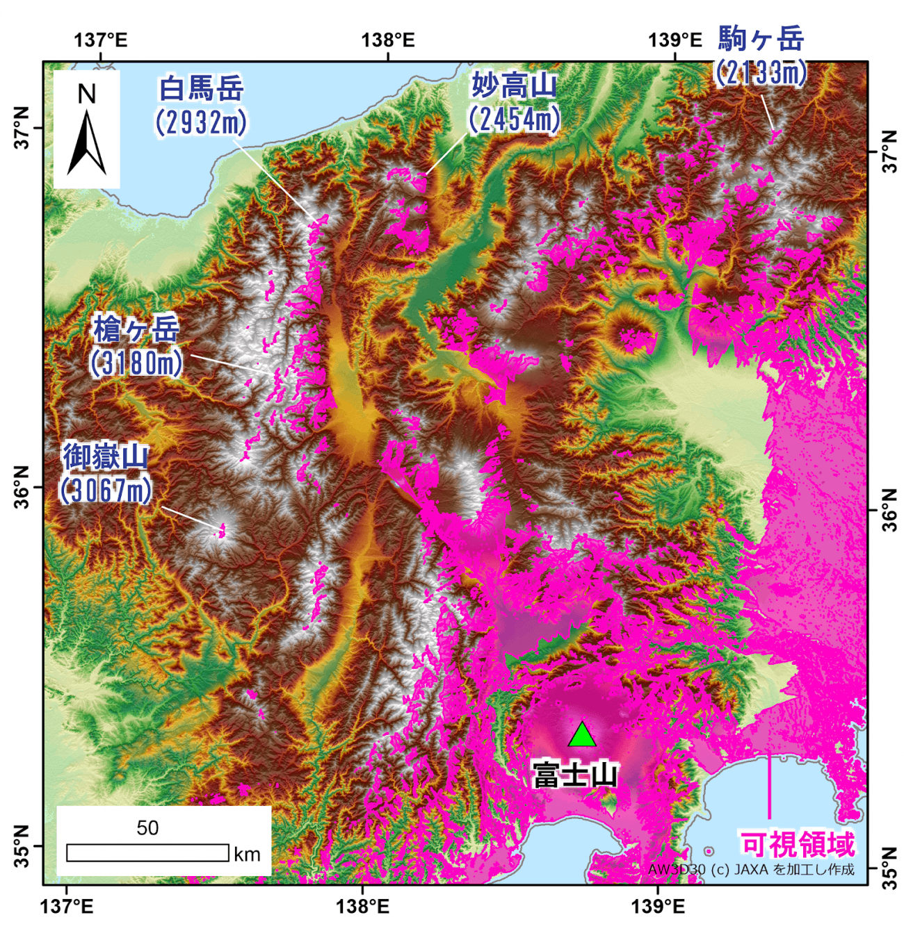
白馬岳(2932m):Mt. Shirouma(2932m)
妙高山(2454m):Mt. Myoko(2454m)
駒ヶ岳(2133m):Mt. Komagatake(2133m)
槍ヶ岳(3180m):Mt. Yari(3180m)
御嶽山(3067m):Mt. Ontake(3067m)
富士山:Mt. Fuji
可視領域:visible area
The visible areas are sparsely located in the Northern Alps, such as Mt. Shirouma (2932 meters), Mt. Yari (3180 meters), and Mt. Myoko (2454 meters).
In the direction of Niigata Prefecture (Echigo), Mt. Fuji can be seen from Mt. Komagatake (2133 meters).
The map (see image #4) shows that Mt. Fuji can only be seen around the limited location near summit of either mountains mentioned above, and cannot be seen from the areas halfway up the mountain due to interruption of other mountains.
Mt. Fuji seems not visible from Mt. Ontake (3067 meters) also, unless climbing up near the summit.
Like this, visible areas are sparsely located around the limited area near the summit due to its high elevation in the region of Japanese alps.
5.The Areas Which Mt. Fuji Is Visible
Last but not least, how about the visible area of southern Chubu to Kinki Region?
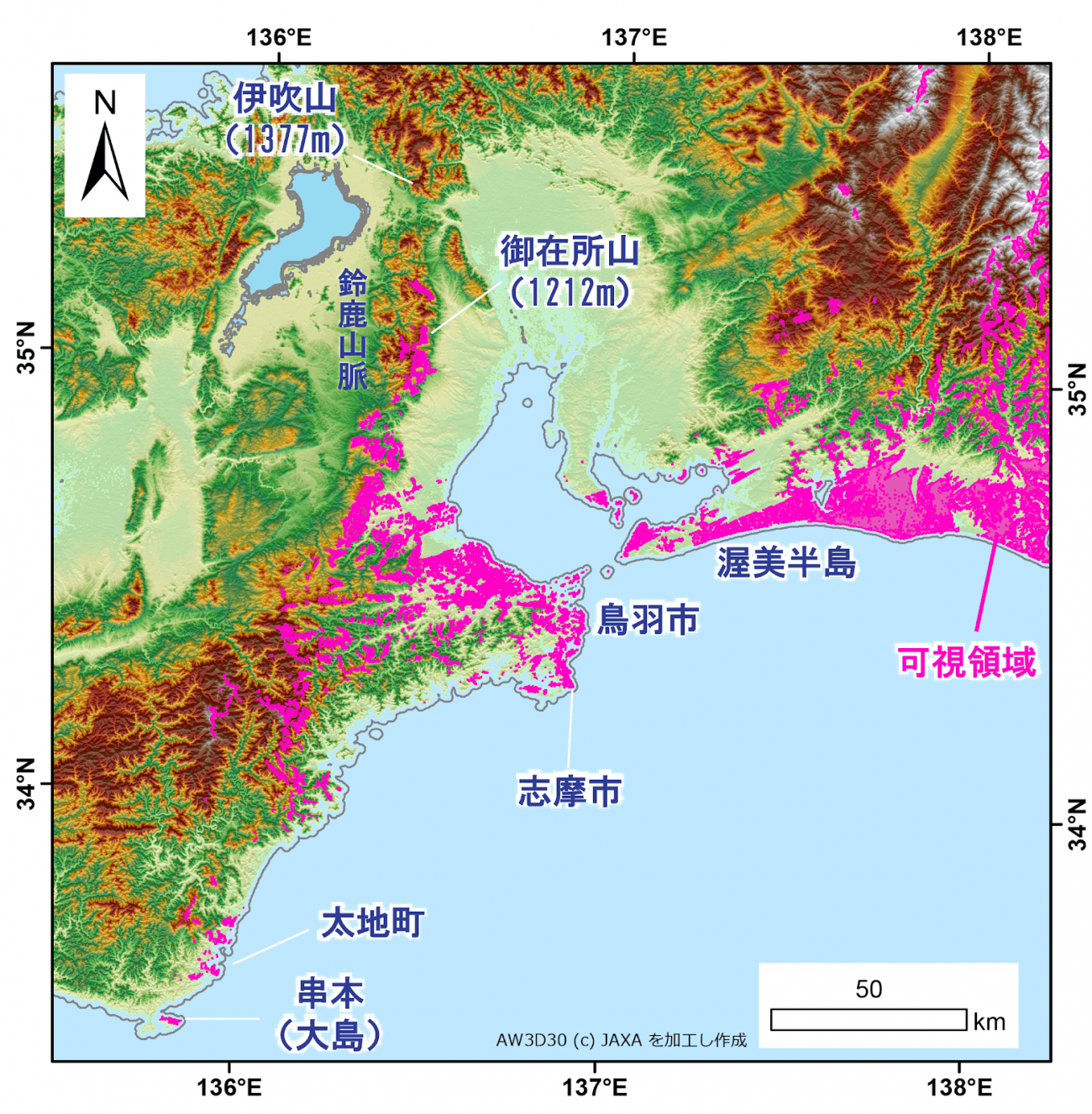
伊吹山(1377m):Mt. Ibuki(1377m)
御在所山(1212m):Mt. Gozaisho(1212m)
鈴鹿山脈:Suzuka Mountains
渥美半島:Atsumi Penninsula
鳥羽市:Toba
志摩市:Shima
太地町:Taiji
串本(大島):Kushimoto(Oshima)
可視領域:visible area
Investigating the map (see image #5), it turned out that the most distant visible area of Mt. Fuji was part of Kushimoto (Oshima) in Wakayama Prefecture.
It seems that Mt. Fuji can also be seen around Taiji in Wakayama, a town famous for whaling.
In Mie Prefecture, Mt. Fuji can be seen in coastal areas such as Shima, a city famous for cultured pearls in Ria, and Toba.
In the mountain region of Mie Prefecture, Mt. Fuji can be seen around the summit of Suzuka Mountains, such as Mt. Gozaisho. However, Mt. Ibuki located in the north of Suzuka Mountains seems to be in the invisible area of Mt. Fuji.
Although coastal area such as Atsumi Peninsula is within the visible area of Mt. Fuji, it grows more limited in Aichi Prefecture.
The result that “the figure of Mt. Fuji is able to see from Kinki or Tokai Region” may not sound quite fit. Nevertheless, according to this map, it is able to say that there are visible areas of Mt. Fuji, located sparsely around the limited areas.
However, “luck” may be needed in order to enjoy Mt. Fuji from these areas, for the distance is quite far, and the figure gets easily hidden by the clouds or fogs.
6.In Conclusion
Sorabatake: We found out that visible area gets limited due to the terrain of the areas, and that there are chances of catching the figure of Mt. Fuji from unexpected places!
Mr. Nagai: Yes. To sum up the analysis, two things can be said;
●Neighboring areas are not always the best spot in viewing Mt. Fuji
●Distance does not matter much in viewing Mt. Fuji if there are plain or ocean near the area.
As a side note, this data is using the data called “DSM”, which takes account of buildings and forests. In geomorphic analysis, the curvature of the Earth is also considered. By making use of this, it is possible to make a map which shows the area where cellular radio waves and radio waves from TV towers reach.
Sorabatake: Thank you very much! We searched about Mt. Fuji this time, but it may be interesting to search what will it be like with Tokyo Sky Tree and other skyscrapers also.
Personally, I would like to go and see if I can really take a photo of Mt. Fuji using this map! It may be useful in searching for new secret photo shooting spots!
Mr. Nagai: I cannot assure that it is visible, for the weather might influence the view, and there may be objects not reflected in the DSM. However, I think it is interesting to go check the accuracy if you have an opportunity to stop nearby.
Like this, we Sorabatake was able to search for the areas which Mt. Fuji is visible.
If you are interested, please check if you can see Mt. Fuji from your city or from your destination of the trip, or making a map of your own may be fun!
Works Cited:
Ryozo Tatehira. (2002). Construction and Operation of Mt. Fuji Weather Radar. Journal of Geography, 111 (5), 780-782.
