“An In-Depth Explanation of Artificial Satellite Orbits! Types of Orbits and Key Points for Selecting Orbits Based on Applications”
How do artificial satellites orbit? This is the first instalment of a series explaining artificial satellite orbits, and it will thoroughly explore the relationship between orbits and their purposes!
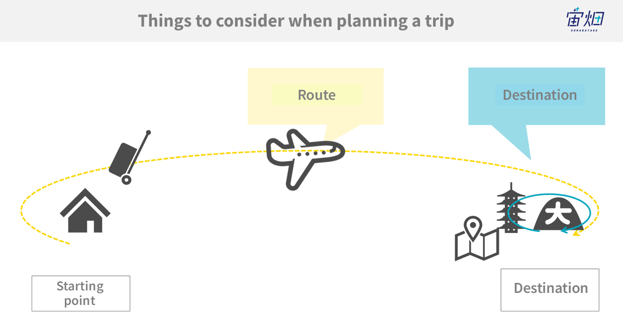
What do you think about when planning a trip? Most people probably start by deciding on their “destination” and the “route (how to get to that destination).”
On the other hand, in the vastness of outer space, destinations like the International Space Station or the Moon are constantly moving. Therefore, they are represented not as fixed points but as “orbits” with velocity. Furthermore, the “routes” to reach these destinations are also expressed as “trajectories,” which are the paths that spacecraft and satellites themselves follow.
Understanding the orbits of satellites and spacecraft involves grasping two types of orbits: one as the “destination” orbit and the other as the “route” orbit. In Japanese, both are commonly referred to as “軌道” (kido), but in English, the former is often called an “orbit,” while the latter is referred to as a “trajectory.”
Understanding the orbits of artificial satellites is crucial when considering, “What kind of mission do we want to carry out?” It’s analogous to the importance of determining both the destination and the route when planning a journey.
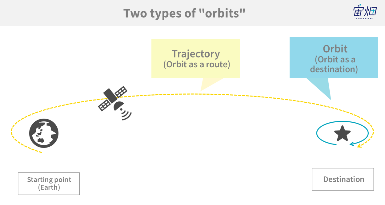
Orbit of Earth Orbit Satellites and Missions
For Earth-orbiting artificial satellites, the type of mission (i.e The services they can provide) varies depending on the orbital path chosen as their destination.
Visible Range and Service Coverage Area
First and foremost, the extent of the visible range and service coverage area that a single satellite can provide is primarily determined by its orbital altitude.
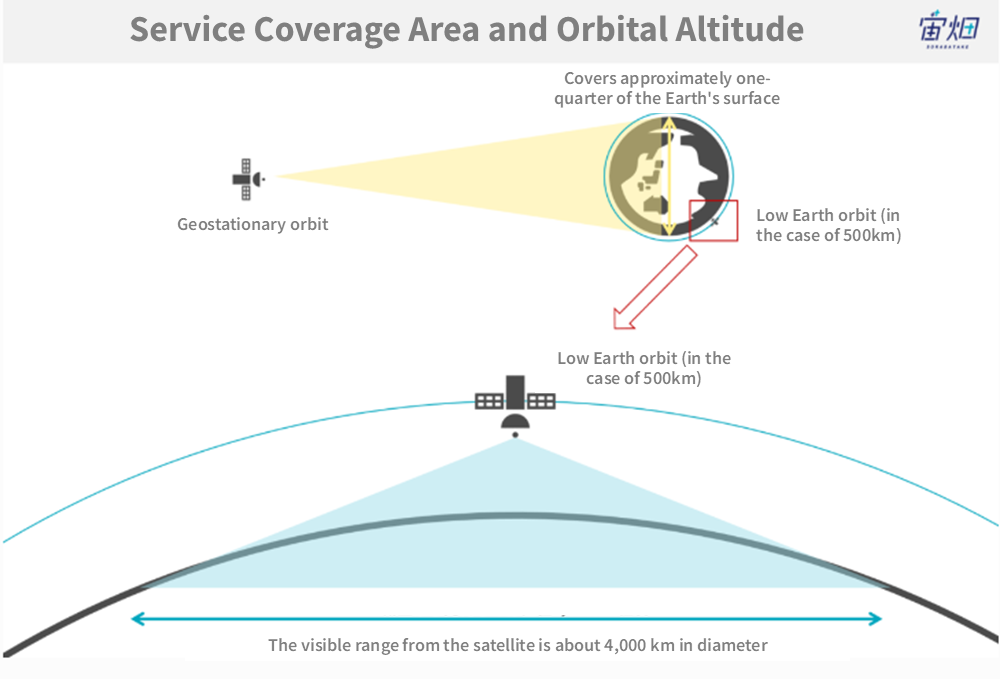
– Geostationary orbit, primarily utilised by weather satellites and communication satellites, is situated at an altitude of approximately 36,000 kilometres, covering approximately one-quarter of the Earth’s surface.
– On the other hand, the “Low Earth orbit,” commonly used by Earth observation satellites, is at an altitude of about 500 kilometres. Satellites in this orbit have a visible range centred around the satellite’s nadir point, extending to a radius of about 2,000 kilometres. In practice, the service coverage area is mostly within 1,000 kilometres or less of the satellite’s position.
Orbital Inclination
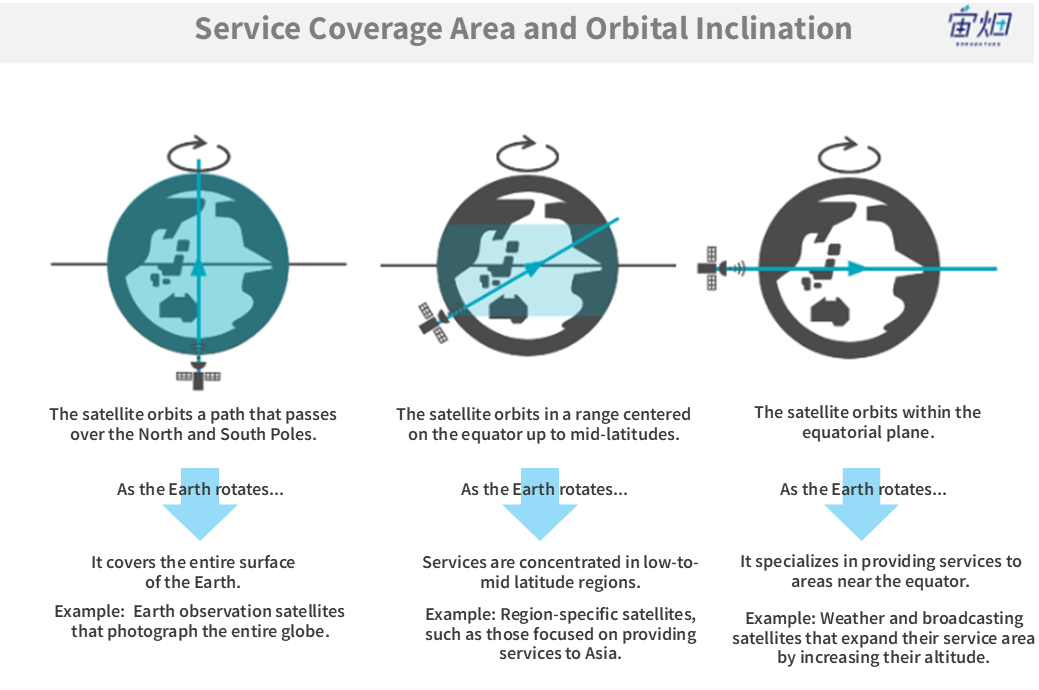
Another crucial factor determining the range of services is the “orbital inclination.” In simple terms, it refers to how much the satellite’s orbital plane tilted relative to the equatorial plane.
– When the equatorial plane and the orbital plane are nearly perpendicular, the satellite’s path will pass over the North and South Poles. As the satellite orbits while the Earth rotates, it provides services by scanning the entire Earth’s surface broadly.
– If the equatorial plane and the orbital plane are not perpendicular but have a slight tilt, the satellite will not pass over the North and South Poles. Instead, it will concentrate its services in mid to low latitudes.
– Furthermore, when the equatorial plane and the orbital plane nearly coincide, the satellite will only provide services to areas near the equator. As mentioned earlier, in low Earth orbits, the observable area is limited, so this type of orbit isn’t very useful for countries outside the equatorial region. However, by raising the altitude, you can create a very convenient orbit with a broader area of coverage. This is known as a “geostationary orbit.”
Observation Frequency
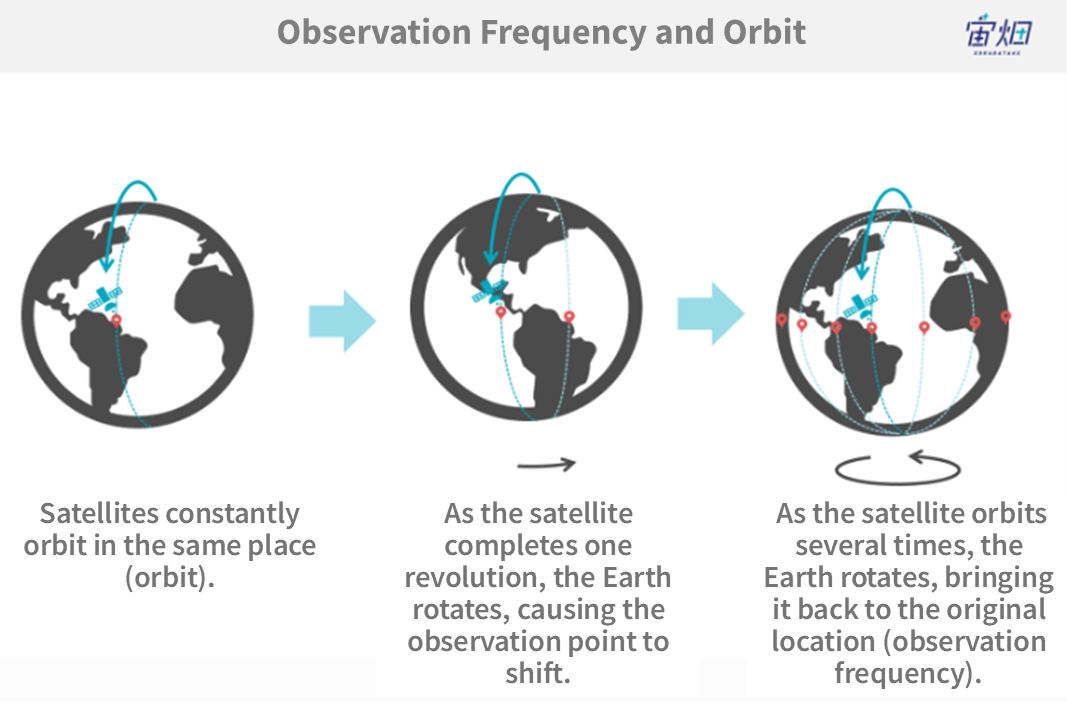
The speed at which a satellite orbits and the Earth’s rotational speed determine how often a satellite revisits the same point on Earth. Detailed explanations are beyond the scope of this article, but by adjusting the orbital altitude and the orbital inclination mentioned earlier, the frequency at which a satellite revisits the same location is regulated.
A “geostationary orbit” is an example of this adjustment. When the altitude is set to 36,000 kilometres, the satellite’s orbit matches the Earth’s rotation speed, making the satellite appear stationary from Earth’s perspective. This type of orbit is frequently used for weather satellites and broadcasting/communication satellites.
Resolution
For Earth observation satellites, one crucial parameter is the data “resolution.”
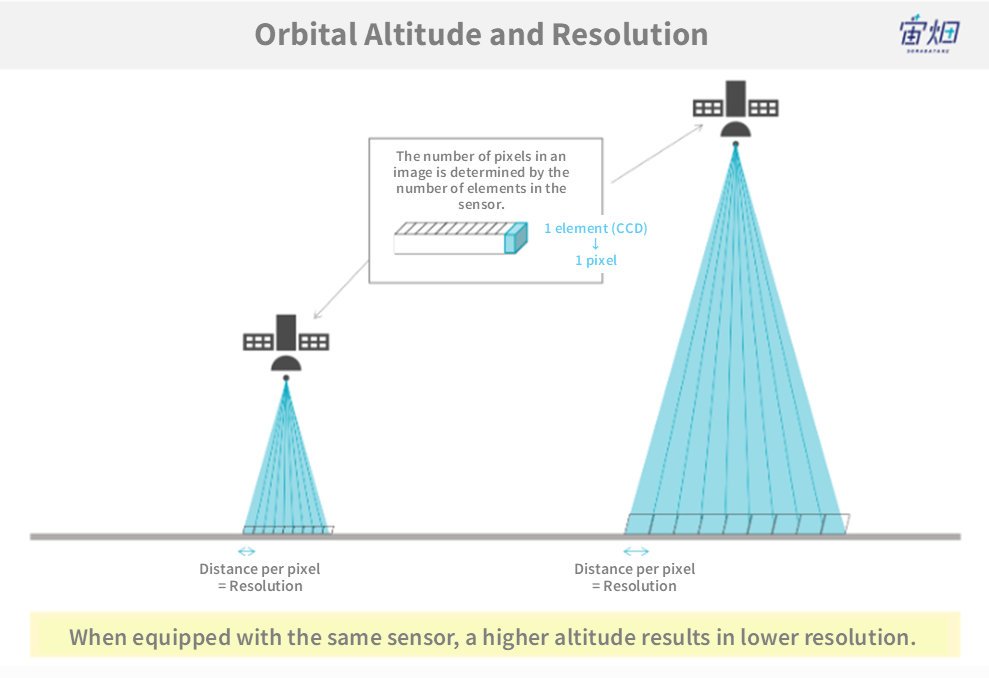
– When considering the orbit, lower altitudes provide better resolution since the satellite is closer to the observed object. Conversely, higher altitudes result in lower resolution.
– While lower altitudes seem favourable for resolution, as explained earlier, they limit the area that can be observed at one time. Thus, the final choice of orbit balances these factors.
– Furthermore, even in outer space, low orbits contain some atmosphere, causing the satellite to gradually lose altitude due to atmospheric drag. This necessitates additional equipment to maintain the orbit.
An example of a satellite with a very low orbital altitude is Albedo’s satellite. By placing the satellite in a low orbit, they plan to achieve image resolutions of around 10 centimetres, which was previously unattainable with conventional satellites.
On the other hand, weather satellites, like the Himawari meteorological satellite, are examples of satellites in higher orbits. Himawari, located in a geostationary orbit, has a wider field of view and can track movements at minute intervals.
Observation Timing (Solar Synchronisation Orbit)
For optical satellites, the angle at which the Sun illuminates the Earth’s surface is also a critical factor.
– If one image is taken in the early morning and another in the evening, the angle of sunlight differs, causing variations in shadow formation, making it difficult to compare the two images.
– To facilitate easy comparison over time, orbits are designed to pass over the same location at the same time, and these orbits are termed “solar synchronous orbits.”
Communication Delay
For communication satellites, an important service indicator is “communication delay,” which measures the time it takes for transmitted information to reach the recipient.
Since the speed of electromagnetic waves (radio waves) is constant, communication delay increases as the distance between two parties increases. You might have seen this phenomenon when there’s a time lag between a Japanese studio and a reporter in a foreign country during a TV broadcast.
In terms of satellite orbits, communication delay increases as the orbital altitude becomes higher.
Conventionally, communication satellites have been placed in geostationary orbits at an altitude of 36,000 kilometres to fix their “service coverage area.” However, in recent years, plans have been developed to place satellites at lower altitudes, around 500 kilometres, to reduce communication delay and other reasons. In this case, each satellite’s service coverage area is smaller and constantly changing. Consequently, the plan involves deploying a large number of satellites, working as a satellite constellation, to provide services.
Orbits and Missions for Destinations Beyond the Moon
Up to this point, we’ve explained orbits in relation to circling Earth (i.e., Earth orbit). However, Earth orbit is just a small part of the knowledge required, especially when heading to destinations like the Moon, Mars, or even farther into space.
From the perspective of choosing an orbital path as a destination, just like with Earth orbit, it depends on the form of the mission you want to accomplish. For example, a mission related to lunar communication would involve selecting a specific orbit.
Regarding orbital paths as routes for travel, similar to planning transportation routes, the choice of orbital path in space has a significant impact on travel time and cost. Especially in the case of artificial satellites, spacecraft, and rockets, there’s a limited amount of fuel that can be carried. If too much fuel is loaded, there won’t be enough space for instruments or equipment. Therefore, designing an orbit that allows for the most efficient travel with minimal fuel consumption is a crucial consideration.
Summary
In this article, we have explained the relationship between satellite missions and orbits. In the next article, we will delve into orbits using Python to provide a more detailed explanation. Stay tuned!
