Earth’s Surface Temperature Data taken by “Shikisai” (GCOM-C) will be Released on Tellus!
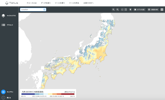
Data showing the temperature of the earth's surface taken by GCOM-C (Shikisai) is available on Tellus after an update on March 26th, 2020. This article goes into GCOM-C's data on the earth's surface available on Tellus OS, and how to read it.
Observational data from the JAXA satellite “Shikisai” (GCOM-C) on atmospheric temperatures has been available on Tellus since December 11, 2019.
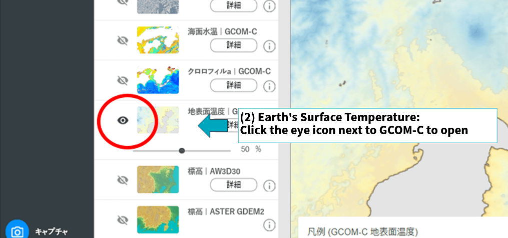
Up until then, Tellus provided data from Shikisai on “sea surface temperatures” and “chlorophyll a concentrations,” but the update on March 26 made data on the earth’s surface temperature available as well.
This article will go over the data on the earth’s surface and how to read it on Tellus.
1. Summary of the Data
Shikisai is JAXA’s satellite used to observe climate change, equipped with a “second generation global imager” (SGLI) optic sensor that observes multiple wavelengths ranges from near-ultraviolet to thermal infrared (380nm~12µm) and is capable of observing 28 different climate changes spread across the four categories of clouds, aerosol (dust in the atmosphere), sea color, and vegetation for half of the earth in one day, and the entire earth in two.
For more details on GCOM-C, check out these articles that were released in the past on sorabatake.
Check out the sea surface temperature and chlorophyll a concentration! Satellite data of SHIKISAI (GCOM-C) is released on Tellus!
Check out sea surface temperature and chlorophyll a concentration! SHIKISAI (GCOM-C) satellite data is released on Tellus!
2. How to Examine the Earth's Surface Temperature Data on Tellus OS
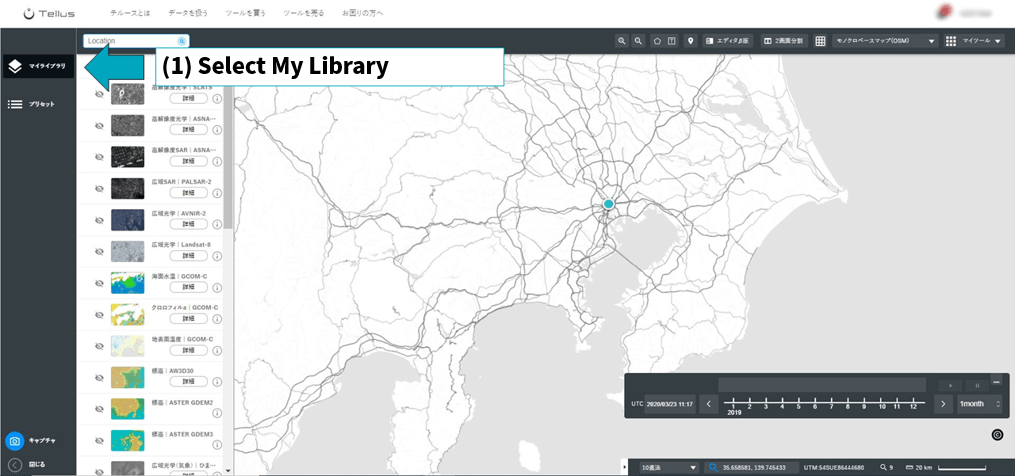
First, make an account by inputting the necessary Tellus information and log in to Tellus OS.
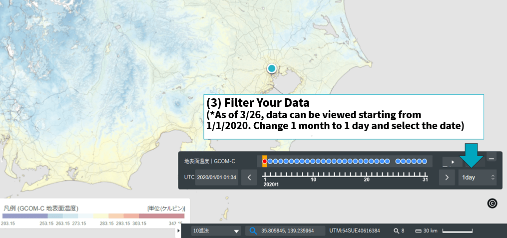
You may notice that the surface temperature in open fields is different from mountainous regions, for example. It might be a good idea to look at differences in seasons and weather and their relationship with the temperature of the earth’s surface temperature.
3. Applications for Data on the Earth's Surface Temperature
How useful is knowing the earth’s surface temperature?
We have introduced the following examples of how knowledge of temperature has helped us in the past.
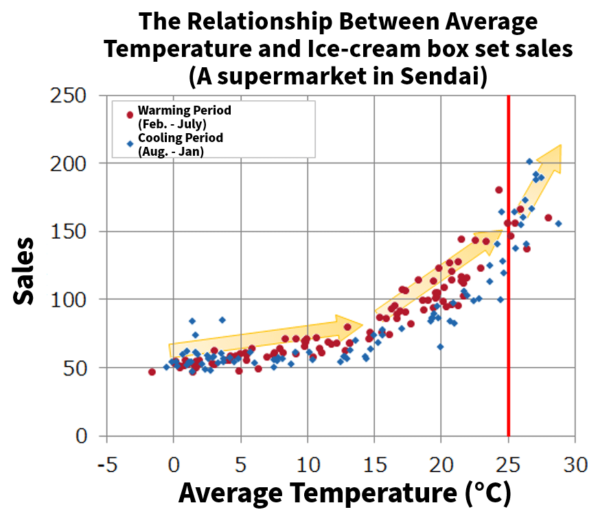
- Predicting which products will sell better more
POS data helped us understand that ice-cream sells better on hot days, and when the temperature declines quickly, oil fan heaters sell more too. Understanding the earth’s surface temperature may help to predict how people will act with temperatures change.
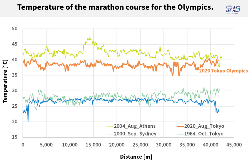
- The risk of heatstroke for a marathon course
In summer, the surface temperature of asphalt gets very high, and therefore, the risk of getting heatstroke also rises. In the future, we will probably be able to check the surface temperature and assess the health risks for marathon runners as a part of taking heat measurements for the Tokyo Olympic Games, as well as study if the marathon course is appropriate by combining the altitude data and wind speed data of Amedas.
4. Summary
We have been looking at the earth’s temperature data provided by Shikisai (GCOM-c) that was released on Tellus from March 26, 2020. The period of data available on Tellus is still limited, but this will be added to via updates incrementally over time.
Data on the sea and the earth’s surface temperature and chlorophyll concentrations will be utilized in many different fields. As the future of the space industry continues to unfold, so will the hype centered around it.
Please take some time to think about how else the data provided by the Shikisai (GCOM-C) can be used.
