Is Satellite Data IoT? A Comparison with Airplanes/Drones and other Case Studies
This article broadly introduces features of the data obtained from IoT sensors, including drones, airplanes, and satellites, and how to combine them.
When you are considering a business using IoT sensors, you may start to think “I really wish I could obtain XXX data”.
Although IoT sensors are use
ful tools that can visualize situations on the ground, what and how often the data is obtained varies depending on the sensors. To acquire the necessary information, it is important to know various sensors and select the appropriate one for your needs.
This article explains the features of IoT sensor data in a broad sense, including drone and satellite data, and their possible combinations.
(1) Data obtainable from various IoT sensors and their features
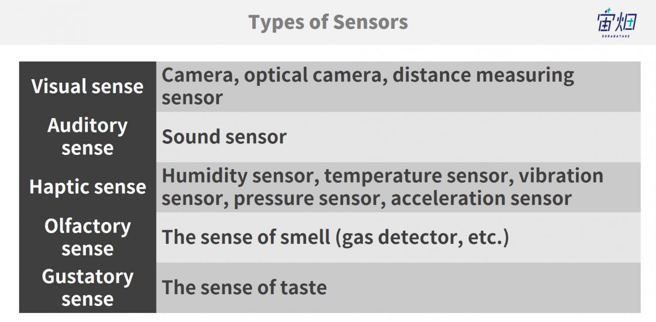
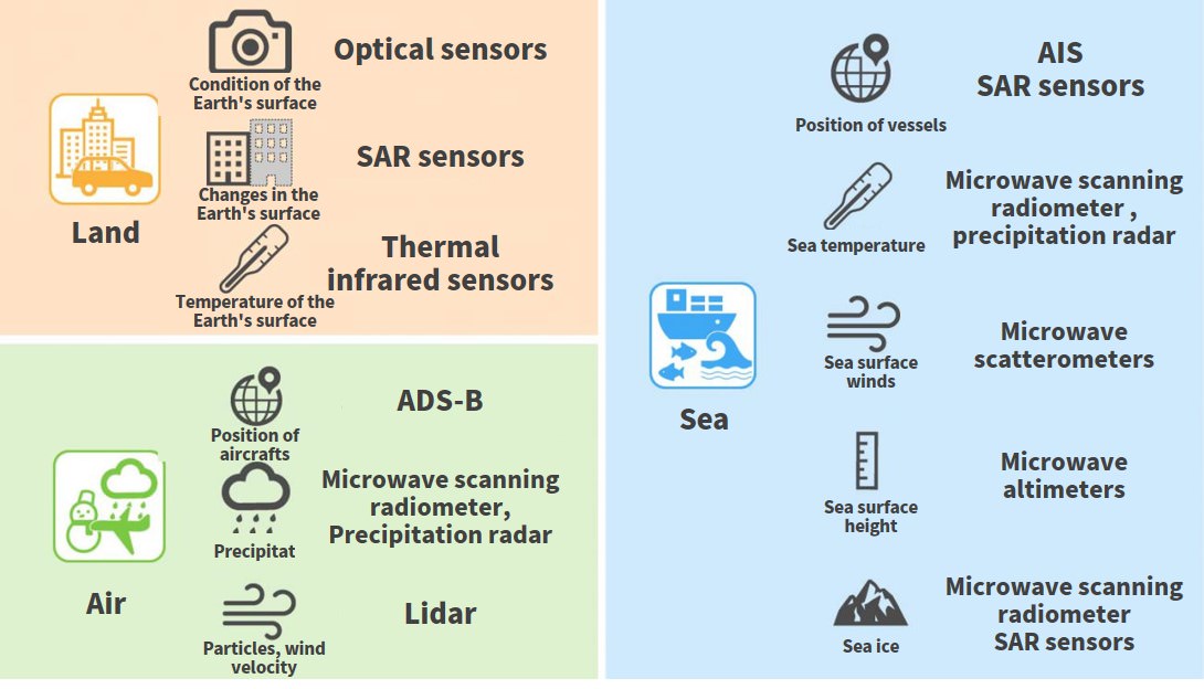
The information that can be obtained through IoT sensors is often likened to our five senses.
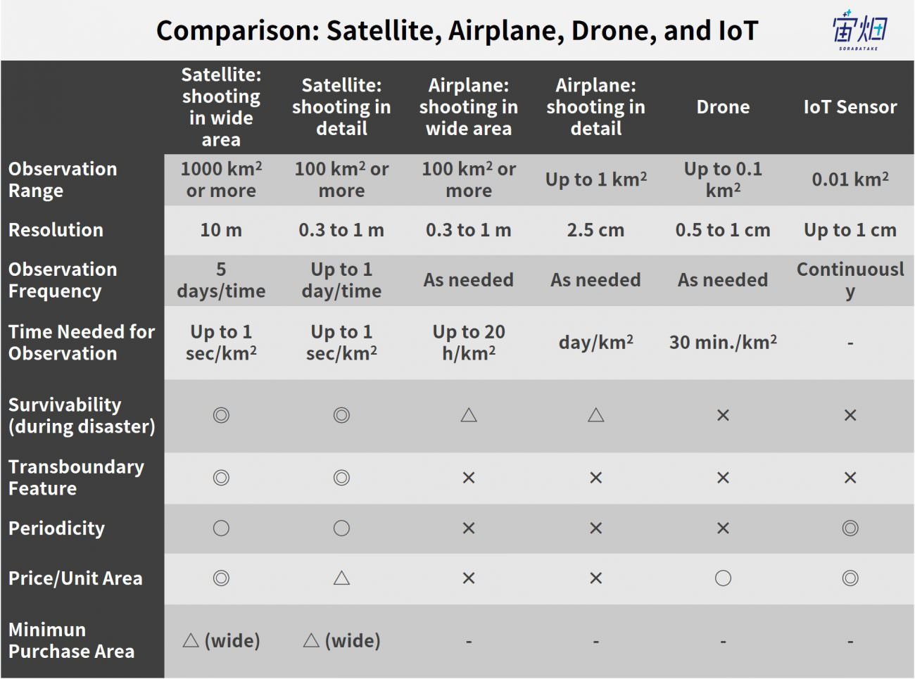
Differences in IoT (direct measuring) sensors, drones, and satellites
IoT is usually set up directly at the location you would like to observe. In addition, acquiring data with drones is also popular in recent years thanks to improvement in batteries.
Moreover, data is also observed further above the drone’s flight altitude by airplanes, and satellites in space.
It can be said that drones and satellites are a part of IoT sensors.
What differences can be seen in these data observation spots?
Direct and indirect ways of measuring (transboundary features and survivability)
The first big difference between ordinary IoT sensors and drones/satellites lies in the method of measurement.
Ordinary IoT sensors are placed at the locations you want to observe, and this observation is carried out in contact with or at close range to the target.
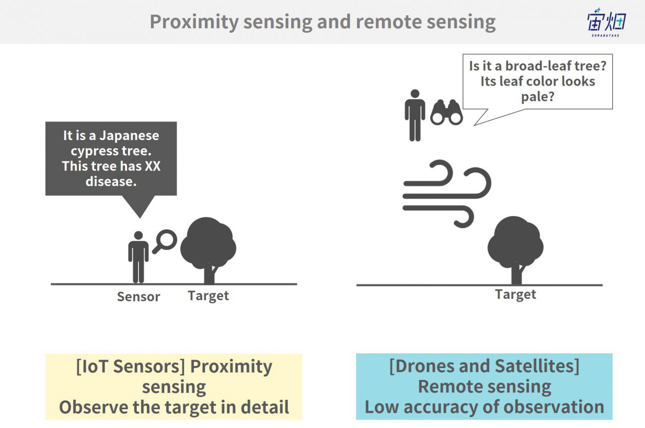
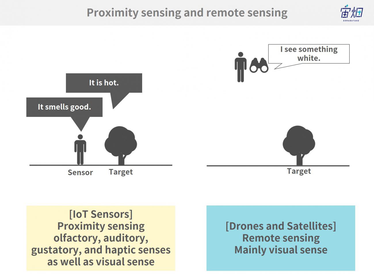
It is, therefore, able to decipher conditions at the target directly, and its accuracy is relatively high. In terms of the five senses mentioned above, haptic, olfactory, and auditory data can only be observed within a close range of the target.
In contrast, observations by drones and satellites are made much further away from the target than ordinary IoT sensors. As the target is measured remotely, their accuracy is limited, and only mainly visual data is obtainable.
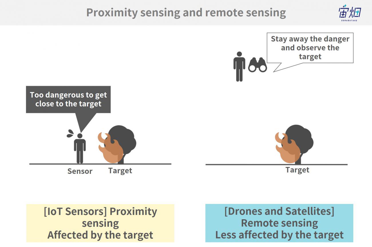
The advantage of measuring data from a distance is that the data is less affected by the environment around the target. For example, you can obtain images during a disaster when the infrastructure on the ground is completely devastated. Furthermore, satellites in space are not subject to weather on earth (though they cannot observe when the surface is obscured by clouds).
Additionally, ordinary IoT sensors and drones are used and operated within the target premises to obtain data, whilst satellites can capture images from outside any such premise.
As stated above, there are differences in the obtainable data, differences in resolution, and advantages of contact sensors and non-contact sensors such as drones and satellites.
Area and frequency of observation (wide-area coverage and periodicity)
The sensor’s resolution and measurement range also differ depending on the observation spot.
IoT sensors, which are placed near the target, have the highest resolution; however, their measurement range is very narrow and the obtainable data is focused only on one point.
In contrast, drones and satellites capture images from a distance. The shooting altitudes vary from several tens of meters for drones to hundreds of meters for satellites, which makes it possible to capture a wide area although resolution is limited.
To be more precise, the area a drone can observe in one flight is several square kilometers, and that for a satellite is several hundred to several thousand square kilometers.
Drones and satellites (except for some exceptions) can capture a wider area because they are shooting whilst flying, which in other words means that they cannot keep focus on one point.
IoT sensors can observe images almost constantly within a certain range of communication and storage capacity, whereas drones and satellites cannot because the former has an issue with possible flight duration and distance (several hours/several kilometers) in one flight and the latter with the time needed to return to the same observation point (several days to several weeks).
(2) Adding value by data fusion
The features of sensors in various locations are mentioned in the previous section.
None of them is the single best method of observation. We can pick one that fits the circumstances but can also combine them to optimize their values.
To take the monitoring of water levels of rivers as an example, the transition of rivers can be observed on a regular basis with IoT’s distance measuring sensors.
River monitoring has only been conducted at first-class rivers, and conditions of second or lower-class rivers has usually only been confirmed visually by municipal officials. With IoT, the condition of rivers can be deciphered more easily and at a lower cost.
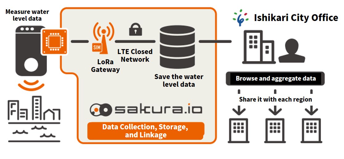
This is a good example of IoT utilization in which detailed information on water levels is always available in real time.
You can get further information by combining this with satellite data.
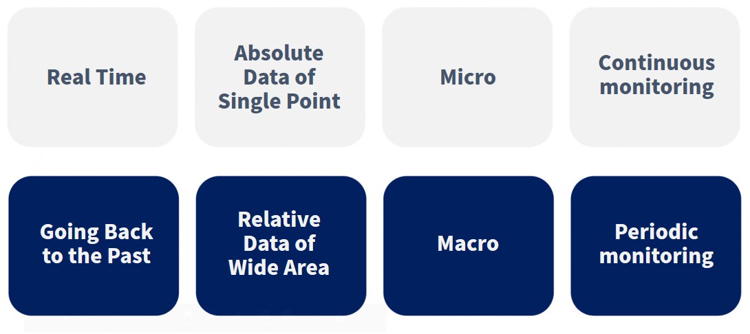
(1) Going back to the past
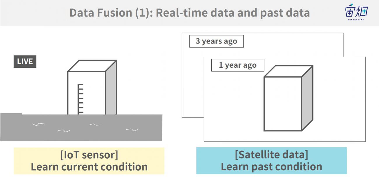
Utilizing satellite data, you can apprehend the situation of rivers even before IoT sensors are installed.
Based on this information, you can figure out the locations where a river may overflow and think about effective locations to put IoT sensors and the risk threshold value based on the IoT data provided by the sensor.
(2) Relative data of the wide area
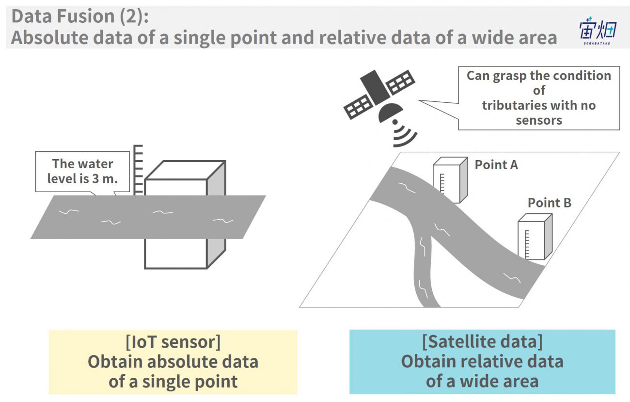
While IoT data is the absolute value at a single point, satellites are good at getting information on a wide area. By clarifying the relationship between the points measured by IoT sensors and wide areas from satellites, you can recognize potential areas of dangerous.
Concretely speaking, by finding out the correlation between the absolute value obtainable by IoT and the relative value of satellite data, you can actually decrease the number of water level indicators installed at various points of the river and can also understand the condition of tributaries flowing into such river.
(3) Macro perspective
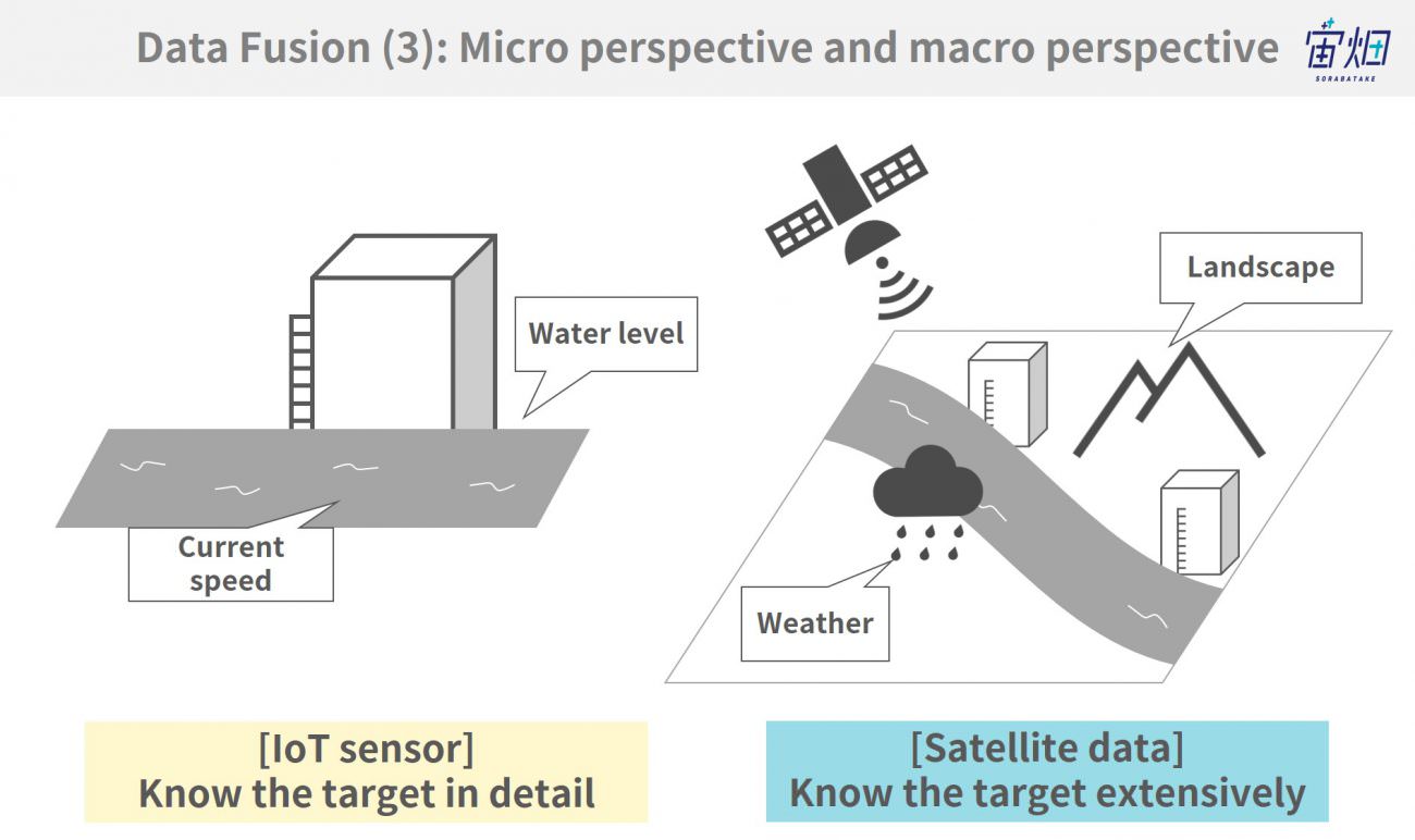
Although satellites cannot obtain needed data at the micro level like IoT sensors, they can, instead, look at things from a macro perspective.
They can also provide mountain rainwater conditions, flowing river water levels and amount of rainfall.
(4) Periodic intervals
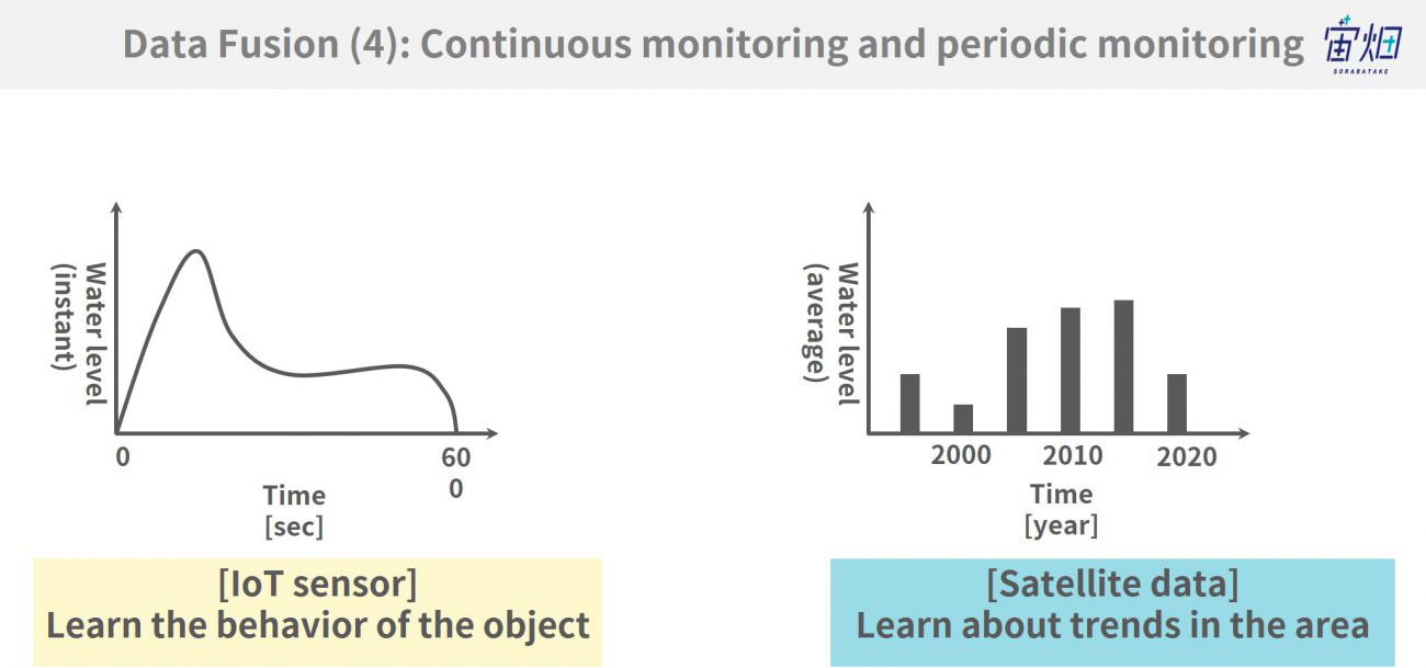
Orbiting the Earth, satellites are not always able to capture data at a single point, but they are suitable for analyzing seasonal or annual trends.
It could be a perfect solution to understand trends at the macro level such as how a rise in sea level affects the water levels of rivers.
The next section will show some case studies.
(3) Case studies of IoT and satellite data
Sensing4Farming:https://explore.digitalglobe.com/Telco-IoT.html
Reference:
Service page:
https://explore.digitalglobe.com/Telco-IoT.html
Press release:
http://investor.maxar.com/investor-news/press-release-details/2018/Maxar-Technologies-DigitalGlobe-Partners-with-Vodafone-to-Create-an-IoT-Precision-Agriculture-Product/default.aspx
DigitalGlobe develops services for the agricultural sector by combining IoT’s directly-measured data and data of a wide range from satellites.
As satellite data can only roughly recognize growth in agricultural land, DigitalGlobe uses IoT data to understand the situation far more precisely.
It is possible to recognize agricultural growth only by IoT sensors if there are enough of them installed. However, it is impractical to place all of them over vast agricultural land. Moreover, they get in the way of farming machines. Thus, it can be considered reasonable in a business sense to install the minimum number of sensors and complement them with satellite data.
Similar to this, there is a case of combining information based on SAR data and ground data.
Reference:
http://www.surveylab.info/en/servizi
http://www.imodi.info/wp-content/uploads/2017/10/Survey-Booklet-ENG_web.pdf
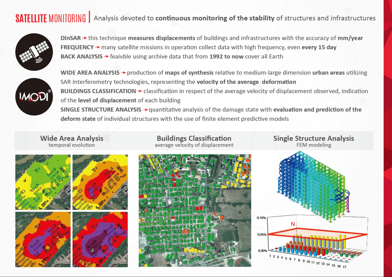
From SAR data which is obtained by observing the reflection of radio waves actively emitted by satellites, you can grasp changes of the earth’s surface. (What is InSAR: obtainable data, cases, mechanism, and interpretation method-https://sorabatake.jp/4343/)
By observing the changes of soil at the macro level and each building at the micro level, it becomes apparent whether it is the building or the soil that is actually changing.
In 2015, there was a bad case in Yokohama in which piling work was not conducted properly. A periodic observation would work as a deterrent to such misconduct, which may help people live more securely.
Besides this, the cases mentioned in the previous articles, “Interview with Seiten No Hekireki: Predicting the Harvest Time in the Extensive Rice-growing Area Utilizing Satellite data” and “Predicting the Electricity Generated by Solar Panels Utilizing Satellite Data: the Methods and Results,” are also considered as examples of combining satellite data and IoT (ground) data.
The former derives absolutely reliable information on agricultural growth by utilizing satellite images to compare the status of each rice field relative to that of others and by actually checking the condition of soil at some rice fields. The latter uses data measured with a smart meter on the ground to improve the accuracy of data calculated based on the information provided by a weather satellite.
(4) Future prospects
Since observation with satellite data and acquisition of data with IoT are both still in the development phase, there are only a limited number of cases that utilize both data in actual businesses, and these are mainly in primary industries.
Although a lot of satellite data is available to the public for free, it has not yet been recognized as usable and therefore has not been fully utilized.
From satellite data obtained at the macro level, you can acquire not only visual information from images but also invisible information, including that related to temperature and atmosphere.
Some new efforts are clear in the following cases: where individuals use their environmental devices to investigate the extent of air contamination in the neighboring region by roughly observing and predicting such contamination by satellite data. Another example is in which future changes of water levels are predicted and managed by a weather satellite while the water level is being observed with sensors installed at the dam.
We have adjusted data based on experiences or observation/work conducted by humans; however, there will be more cases where such human-based operation is replaced by IoT devices. When doing so, by assuming that such devices are paired with satellite data, you can decrease the number of devices to be installed or observe the wider area via satellite, which will make it possible to reduce cost greatly or/and increase added value.
The ability to optimally obtain both macro and micro data could be an important skill to survive in the big data society of the future.
