Automatic extraction of changes in cities and buildings from two satellite images! New Tellus tool “Tellus-DEUCE” is now available.
We will introduce what you can do with the new Tellus tool "Tellus-DEUCE," released on the 25th of February 2021, which can automatically extract the difference between two selected satellite images using AI, showing some actual screenshots and how to use it.
On February 25th, 2021, the Tellus-DEtector on Urban ChangE, commonly called “Tellus-DEUCE,” was launched as a new Tellus tool that can extract changes in satellite images from two different time periods.
SAKURA Internet coordinated The development of Tellus-DEUCE, was coordinated by SAKURA Internet and ABEJA Inc., which was involved in the social implementation of AI, using algorithms. A prototype of the tool, which can extract changes in satellite data between two different time periods, is available on the Tellus OS for free at Tellus Market. It can also be used as an API in an analysis environment.
For more information, please see the following press release.
衛星データプラットフォーム「Tellus」、ディープラーニングで衛星画像の差分を自動抽出するツールの無料提供開始~衛星画像から、街や建物の変化を自動解析することが可能に~
This article provides an overview of Tellus-DEUCE and what you can do with it.
What is Tellus?
Tellus is a Japanese open and free platform that allows users to analyze satellite data on cloud with the aim of creating new businesses for industry.
Tellus offers not only satellite data, but information on the movement of people, climate data, and promotes the cross-referencing of such data to create new business models.
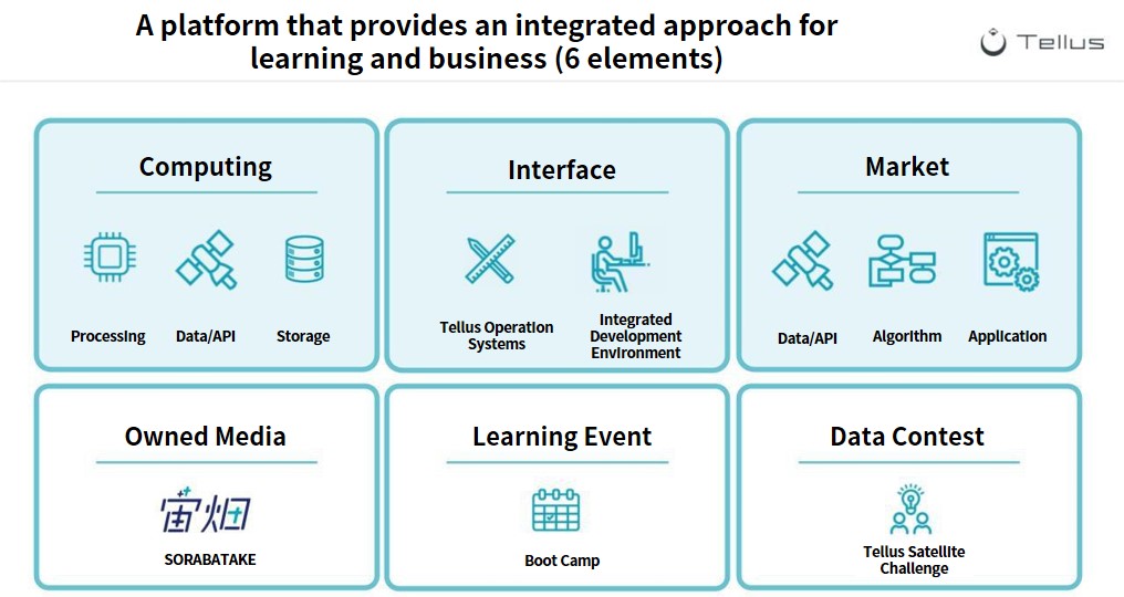
Tellus currently has 6 different functions available with the aim to promote new business ideas.
As of February 2021, two years after its launch on the 21st of February 2019, Tellus has more than 20,000 registered customers and is constantly working on various initiatives and updates.
The market for buying and selling tools, including data, APIs, algorithms, and applications, is also gaining much momentum. Please take a look at the tools that have been implemented by various companies.
★Try out Tellus for yourself! Click here to check out Tellus!
[Tellus Ver.2.0 Released] The Redesigned Website, Improvement of the UI of the OS, Newly Opened Market
【Now available at our Tellus Market!】It’s now possible to sell tools on Tellus! Increased browsing speed and new functions available on update.
Development Background
SAKURA Internet and ABEJA have formed the “xDataAlliance” partnership, in which they aim to develop and promote together the use of Tellus. The “Difference Extraction Tool/Tellus-DEUCE”, released this time, is a prototype tool, for which SAKURA Internet coordinated the development and ABEJA implemented the algorithm using their deep learning technology. It is offered free of charge as an official Tellus tool at Tellus Market.
Note by Sorabatake: xData Alliance
A partnership formed to promote the development and use of Tellus. Not only space-related companies but also companies from various industries are participating in the partnership.
If we can extract changes in satellite images from two different time periods, as we have done with this tool, we will be able to understand the construction status of buildings globally, the effects of disasters, and any other remote area.
It can be used in a variety of industries, including the real estate industry for building reconstruction, the financial industry for economic growth of cities, the insurance industry for the extent of disaster damage, and the trading and construction industries for monitoring the progress of construction and development overseas.
In a previous interview with ABEJA about their thoughts on this project, the project manager, Mr. Ryusuke Sakuma of ABEJA, said, “By using image recognition and image processing to compare satellite data from different time periods at the same location, it may be possible to retrospectively analyze changes in various terrains and the degree of evolution of buildings and cities. Furthermore, we may be able to predict the future.”
Please take a look at Mr. Sakuma’s passionate thoughts on the affinity between satellite data and machine learning, which will help you better imagine the future of the space business.
The “Extracting Difference Between Two Points of Satellite Data” Challenge — A Look at ABEJA’s Difference Extracting Algorithm
Features
Tellus-DEUCE is a tool that can automatically extract changes (differences) in satellite images of two arbitrarily selected time axes using deep learning technology.
We provide it as both an API and an add-in at the Tellus market, so you can perform differential extraction on TellusOS even if you do not have a development environment.
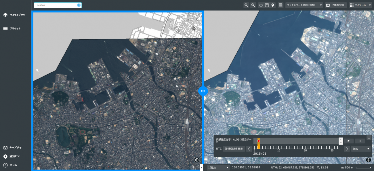
With Tellus OS, you can compare two satellite images side by side, as shown in the following screenshot. For example, below are two satellite images of Fukuoka City on the 2nd of August 2015, and on the 15th of May 2019.
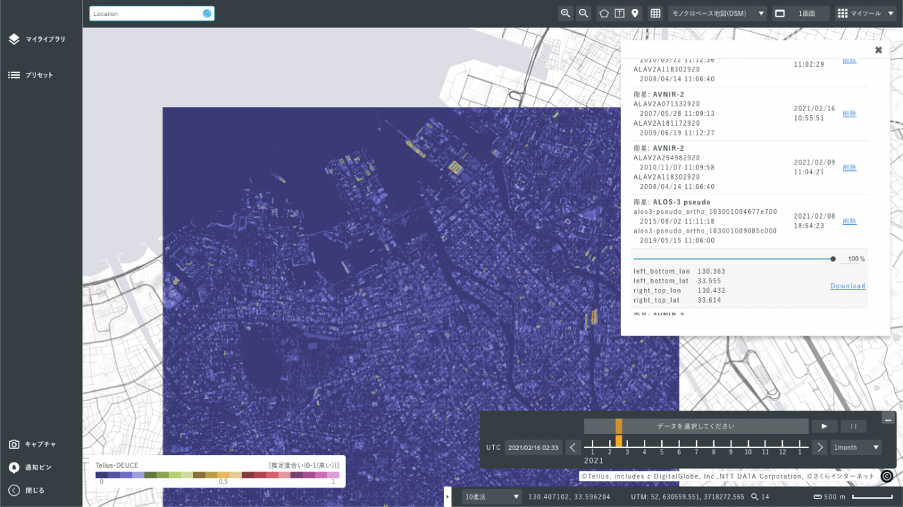
As you can see, it is possible to compare two images and look for patterns of change visually, but by using Tellus-DEUCE, it is possible to automatically extract the areas that have changed and visualize the changes.
The following screenshot shows the extracted difference between the above two images. You can see that the ship docked in the upper part of the image in 2015 is gone in 2019.
The specific procedure for extracting differences in Tellus OS using Tellus-DEUCE is as follows.
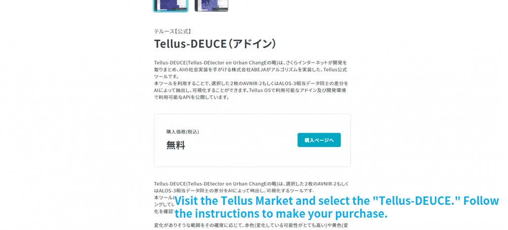
Visit the Tellus Market and select “Tellus-DEUCE.” Follow the instructions to obtain the tool.
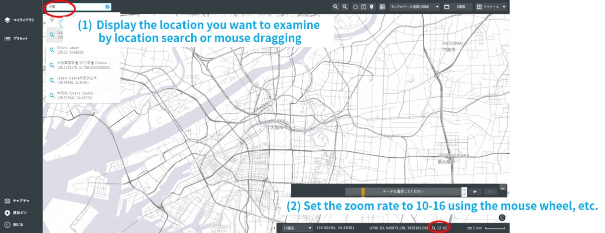
Open Tellus OS, display the point you want to examine, and set the zoom rate to 10-16.
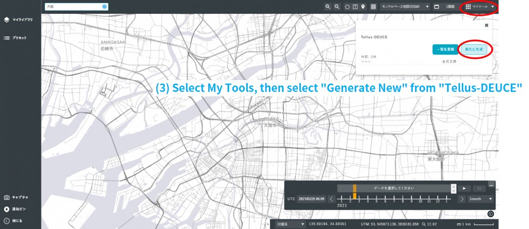
Open the “Tellus-DEUCE” that you have just acquired from My Tools in the upper right corner of the screen and select “Generate New.”
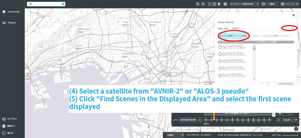
Select a satellite from AVNIR-2 or ALOS-3 pseudo and click “Find Scenes in the Displayed Area.” Select the first scene displayed and see if it is the point you want to check. If the differences cannot be extracted properly, please slightly shift the area where you want to compare differences.
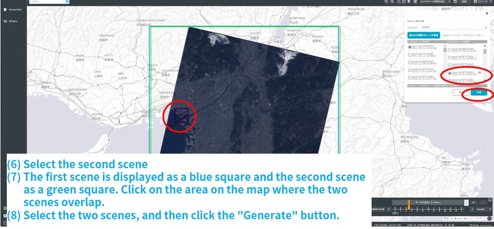
Once the first scene is decided, select the second scene in the same way. Scene 1 is displayed as a blue square, and Scene 2 as a green square. Then, select the point on the map where the two squares overlap. Select the point where the two scenes overlap, and then click the “Generate” button.
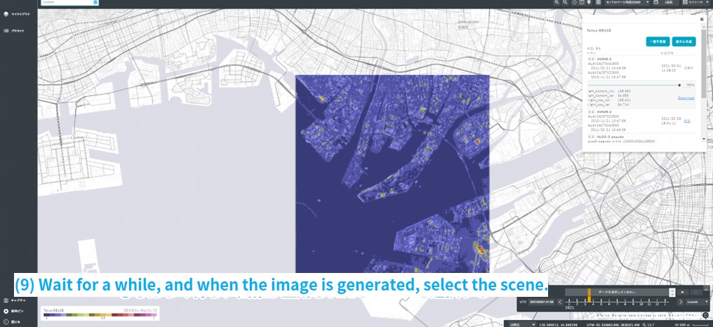
After the generation is complete, select a scene with an area of approx. 6 to 7 square kilometers (Data size: approx. 2 MB (AVNIR-2), 20 MB (ALOS-3 or equivalent) and check the difference between the two time periods. If the generation does not finish, try clicking “Refresh the List.”
Currently, Tellus-DEUCE can extract differences from “AVNIR-2” and “ALOS-3 or equivalent data.” The area is approx. 6 to 7 square kilometers, and the data size is approx. 2 MB for AVNIR-2 and approx. 20 MB for ALOS-3 or equivalent data.
Secondly, Tellus has already produced “TelluSAR” as a tool to compare satellite images from two different time periods, just like Tellus-DEUCE.
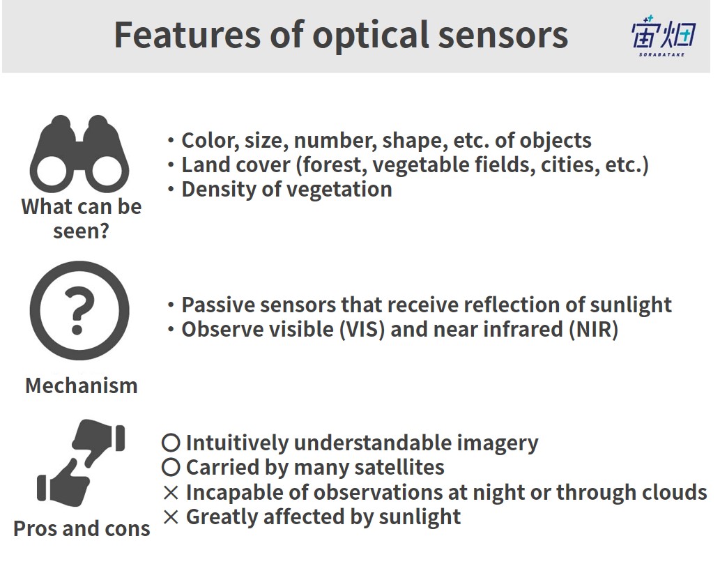
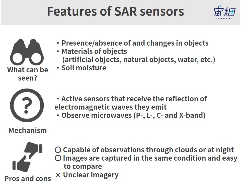
“Tellus-DEUCE” is a tool that extracts differences in optical data, whilst “TelluSAR” is a tool that uses SAR data.
Optical data and SAR data have the following characteristics, and it is helpful to understand the advantages and disadvantages of each and use them accordingly.
For more information on TelluSAR, please refer to this previous article on Sorabatake.
TelluSAR is finally here! Thorough explanation of how to use the official analysis tool”TelluSAR (Teru-sa)” API!
Summary
Now that Tellus-DEUCE can automatically extract changes in data of any location over time, we can streamline what we used to have to confirm visually or by fixed-point observation. By automatically extracting a wide range of information from satellite data, it is now possible to visualize changes in a city, understand the situation at the time of a disaster as well as clearly predict what the future may look like.
If this article has sparked your interest in Tellus-DEUCE, why not register with Tellus? Use the link below, log in to the Market page, and start using Tellus-DEUCE!
