Japanese space startups discuss how satellite data usage can be accelerated
Satellite data in the earth observation field rapidly expands and influences diverse industries, but challenges remain for further diffusion. Three companies (Synspective,SPACE SHIFT,Warpspace) spoke to us about their businesses and the challenges and prospects for satellite data utilization.
Recently, the use of satellite data in the earth observation field has been expanding rapidly for security and disaster prevention and various industries such as agriculture, fishery, environmental monitoring, infrastructure monitoring, insurance, and finance.
However, some issues must be solved before satellite data can be used more generally and widely. In this interview, we talked to three companies, Synspective, SPACE SHIFT, and Warpspace, about their businesses, current issues related to the use of satellite data, and prospects.
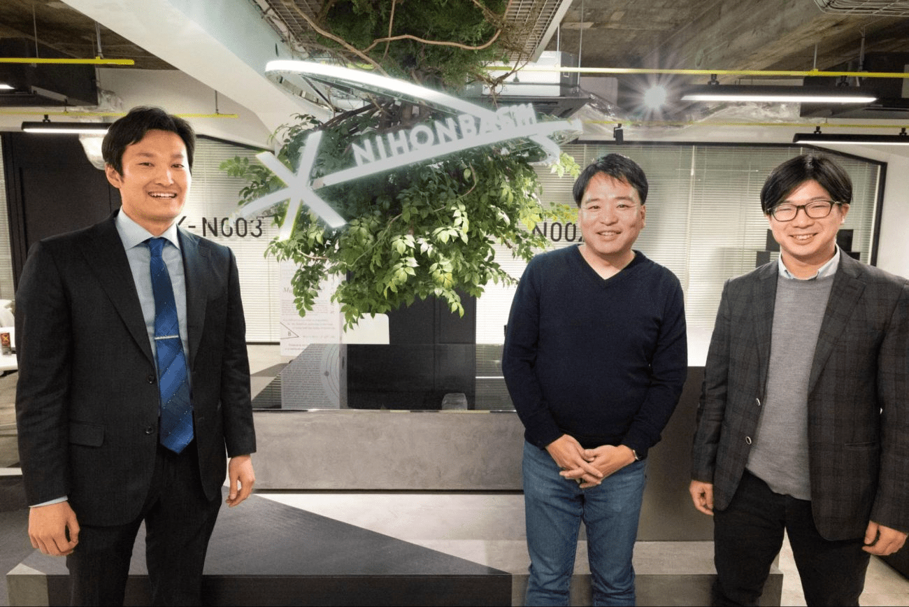
This interview was held at Space Business Hub X-NIHONBASHI
(1) What You Should Know about Satellite Data Utilization
Before we get into the content of the discussion, we have organized the basic knowledge about satellite data that you need to know to think about satellite data utilization.
Please read this chapter before reading the contents of the discussion in order to get an idea of what each company is talking about in terms of their business and prospects discussed in the discussion. You can skip this chapter if you already know what we are discussing.
The Essentials of Satellite Data: What we know, types, frequency, resolution, and Usage
The basics of satellite data — What it tells us, types, observation interval, resolution and use cases
Frequency of Satellite Imaging
For an earth observation satellite to take images of a desired location on the ground, the satellite must pass directly over or near the location to be imaged. The number of days it takes for the satellite to return to the same point is called the “repeat cycle.” The repeat cycle varies depending on the satellite’s orbit, meaning the imaging frequency varies from satellite to satellite. With conventional earth observation satellites, it takes several days to several weeks for a satellite to return to the location of interest, making it difficult to detect changes in ground conditions within a short period and to meet the need for immediate satellite data.
Recently, however, a constellation of satellites launched by multiple nano-satellites has made it possible to observe ground conditions daily (in some cases, multiple times a day). The need for more frequent observations of the same point and the need to know the ground conditions in real time is increasing every year, and there is a need to increase the frequency of imaging further.
Speed of Data Acquisition from Imaging
Data acquired by earth observation satellites are not always directly available. In order to make it available, it must be transmitted from the satellite to the ground station, which can only be done when the satellite passes over the ground station.
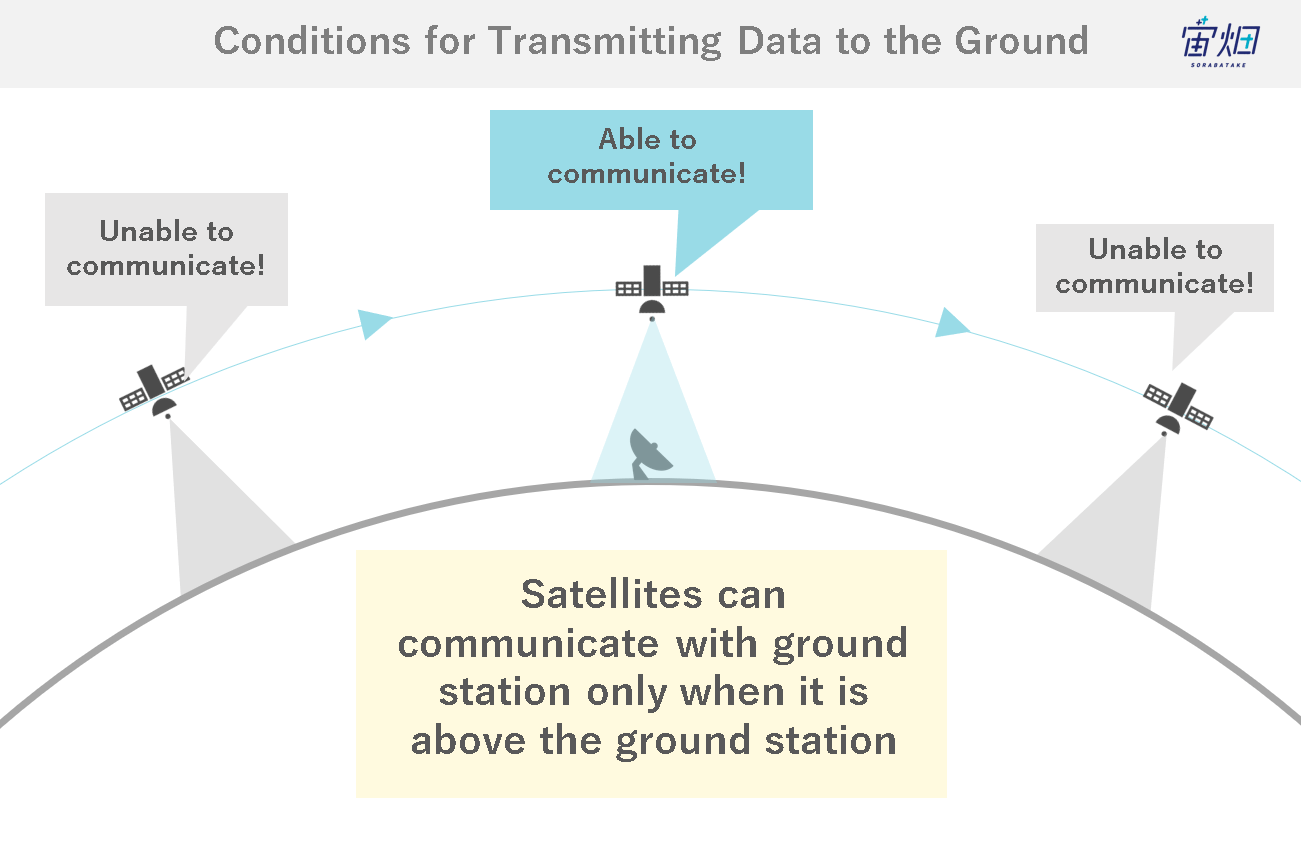
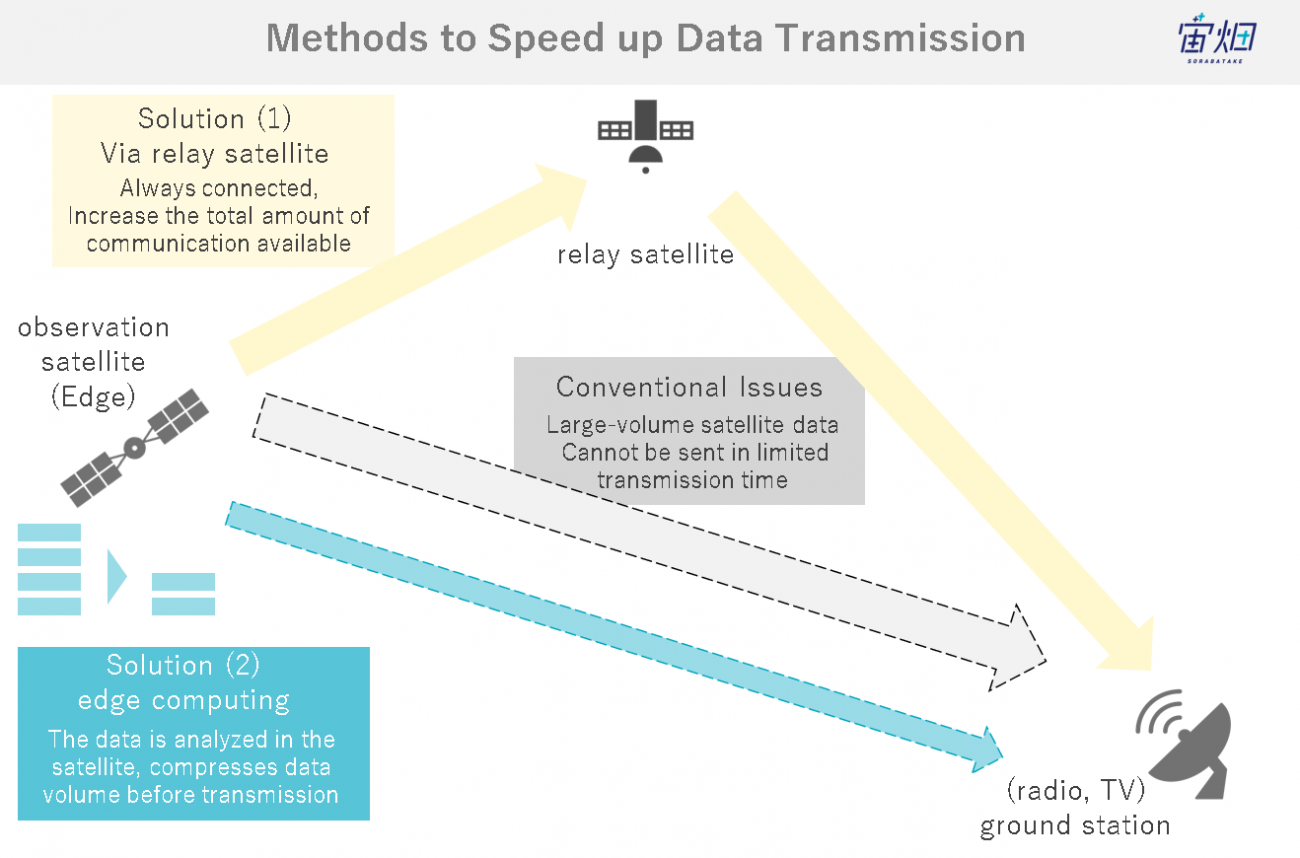
Since satellites image the entire world, installation of multiple ground stations worldwide is necessary to ensure that images taken at any point are immediately transmitted to the ground, but this requires a large amount of investment. In the future, as satellite data becomes of higher quality and more frequent, the amount of satellite data will grow enormously. If communication speeds remain the same, the amount of data that needs to be transmitted will increase, and it may be impossible to send all the data down to the ground at once. Thus, it will take time for the data to reach the user. Therefore, these two technologies are attracting attention in the space industry.
1. Edge computing:
which analyzes and processes data in the satellite, compresses the amount of data to only the necessary information, and transmits it to the ground
2. Optical communication relay satellite:
which enables high-speed, immediate transmission of images when they are required
How to eliminate communication delays and obtain the necessary data at the desired timing is being sought.
Sorabatake Memo: What is edge computing?Data processing at the edge point of a network (in the case of a space system, a satellite).
Resolution of Satellite Image
The degree to which an earth observation satellite can observe ground conditions in detail differs from one satellite to another. The best Ground Sampling Distance (GSD) of current commercial (optical) observation satellites is 0.3m.
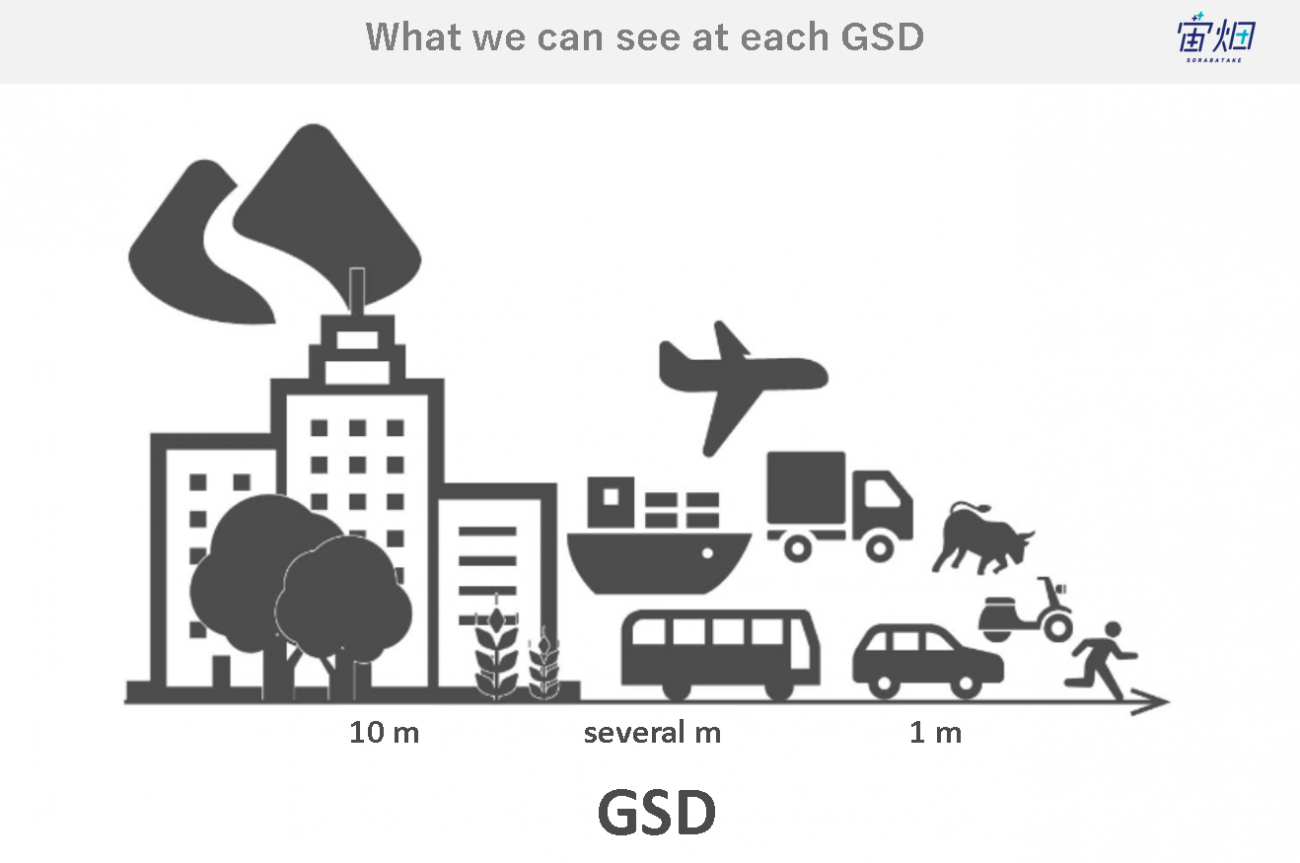
At 0.3 m GSD, the satellite will be able to determine the front and rear orientation of a vehicle and even the presence or absence of people in some cases, but the finer the ground resolution, the higher the data price.
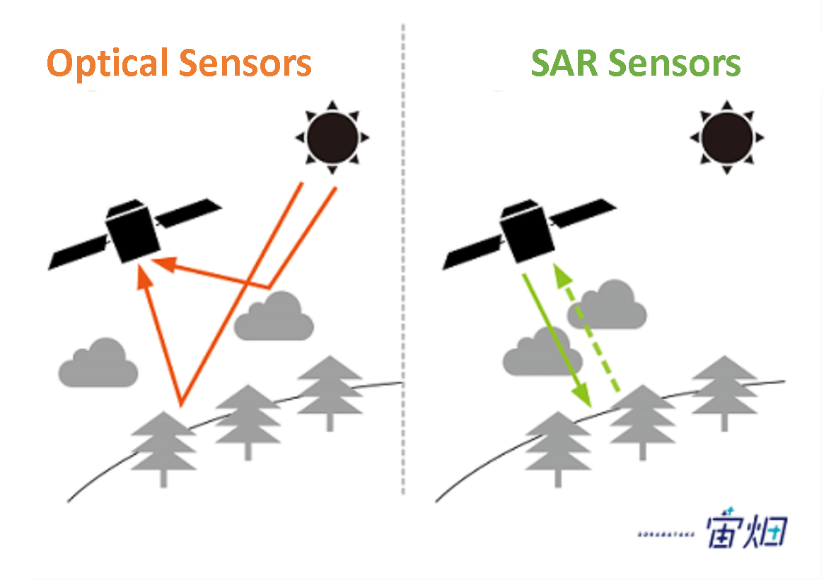
In addition, optical sensors use sunlight reflection and cannot capture images when clouds cover the sky. Therefore, SAR sensors, which can make regular observations regardless of weather conditions, are attracting attention. However, SAR images are black-and-white images that visualize the reflection of radio waves. They are more difficult to understand intuitively than color optical images, so it is necessary to use a combination of various satellites depending on the application.
In this article, we have raised the issues of frequency of satellite imaging, data acquisition speed, and resolution as representative examples. However, many other issues still need to be addressed before satellite data can be more widely used, ranging from difficulties in analyzing and finding user needs to awareness of satellite data.
In the next section, we will discuss what each company is doing to solve these issues and its plans to expand the use of satellite data.
(2) Efforts by Each Company

General Manager, Solution Technology Department, Synspective, Inc.
Mr. Fukuda joined Synspective after gaining experience in providing solutions using data from devices that read human behavior at his previous job. He is in charge of the Solution Development Department.
Mr. Fukuda:We have two major businesses. One is that we develop and manufacture our own small SAR satellites, the “Strix” series, and sell the data acquired from the satellites as they are. The other is to process the data to make it easier for the general public to use and offer it as a solution.
We have a roadmap to deploy 30 satellites in orbit by the late 2020s, and last year we launched the third satellite. We are increasing the number of satellites because the more satellites we have, the more frequently we can acquire data. We assume that the higher the frequency, the more usable the data will be for the general public in the future.
Furthermore, we are building an analytics platform to provide satellite data as a solution. Ultimately, we want to create a situation where everyone can access satellite data through the analytics platform every few hours as soon as they want it.
Sorabatake:So I understand you provide a one-stop service, from satellite development to solution provision. What is the employee ratio between satellite-manufacturing and solution-providing sides?
Mr. Fukuda:Regarding the number of employees, there are more people on the satellite-manufacturing side, and the ratio is 7:3 between satellite-manufacturing and solution-providing.
Sorabatake:Thank you very much. The most recent press release shows Synspective is moving forward with sales partner alliances. Are there any recent topics?
Mr. Fukuda:Our main business is to create and sell satellite data, so we need to build channels to sell it. We are focusing on partners who sell satellite data as it is and who can add value to the data as a solution to solve customers’ problems. Sometimes, we would like to work with our partners to create solutions.
Sorabatake:Do you mean you build the sales structure first and then build the satellite afterward?
Mr. Fukuda:It goes both ways. Of course, developing a satellite after building a sales system is more secure, but considering the competition, it is also necessary to build a satellite to some extent first.
We have a subsidiary in Singapore, and our focus area is Southeast and East Asia, but we would like to expand into Europe and North America.
Sorabatake:Thank you very much. The analysis of SAR satellite data is booming right now, and it is a field expected to grow more and more. Next, Mr. Kanemoto of SPACE SHIFT mainly provides data analysis solutions for SAR satellites. Could you introduce your business?

Representative Director, SPACE SHIFT Inc.
After studying AI as a student and working in the IT and music industries, he established SPACE SHIFT in 2009. He develops automatic analysis technology combining satellite data and AI and promotes satellite data utilization by non-space companies. He has served as a member of the Ministry of Internal Affairs and Communications "Space x ICT" Roundtable Committee and as a specially-appointed researcher at AIST. Deputy Executive Director of NewSpace Research Group.
Mr. Kanemoto:We develop software to analyze satellite data, especially SAR satellite data. We do not develop or own our satellites.
In terms of SAR satellites, we work with satellite operators worldwide, from large satellites to microsatellites, in the U.S., Europe, and Japan.
Our goal is to develop software that can automatically obtain the information we want as a virtual constellation by combining data from all types of satellites, from optical and SAR, from large to nano-satellites, without relying on any specific satellite, in order to allow users to see what they want to see and when they want to see it.
Sorabatake Memo: What is a virtual constellation?Virtual constellation refers to using satellites operated by multiple companies and institutions, and each is regarded as a single virtual observation network.
By the late 2020s, a total of about 200 SAR satellites will be available for utilization, and if all 200 satellites can be combined and analyzed, we will be able to see anywhere on Earth once every 5 to 10 minutes. We are developing AI for this purpose, which will be helpful like a middleware.
Most recently, we have increased the number of deep learning engineers, and this year we will also establish bases in the United States and Luxembourg to build a foundation for overseas expansion.
Sorabatake:Your data combining from various satellites is a distinctive feature of your work. Is there anything else you are working on?
Mr. Kanemoto:Yes, we are. We are also thinking of working on edge computing.
Data will increase significantly with the launch of 200 or 300 SAR satellites for regular use. The data is expected to be available for immediate downlink whenever the world needs it, but the volume of data is so huge that it will take time and cost much money to send all the data to the ground.
For example, when there is a need to find a ship, it will be possible to send very light information to the ground, such as the latitude and longitude of the ship and the type of ship, because the data can be converted into text information. If you want more detailed information, you can send down only the necessary part of the data.
As software developers, we focus on who wants what from the onboard applications, where the needs are, and what kind of algorithms and accuracy should be required. We are looking for orbital demonstration opportunities for this purpose.
As a recent topic, we are working with AWS (Amazon Web Services) to monitor the growth of leeks in Tottori by using and analyzing ground data read from sensors and satellite data.
SPACE SHIFT Develops AI-Based Precision Agriculture Solution on AWS
This will evolve as an application by managing ground data and satellite data together on a cloud platform like AWS. If all the data is deployed on the cloud, it will be more convenient and ready to use.
Sorabatake:Thank you very much. Lastly, Mr. Mori from Warpspace, could you introduce your business?

Space Business Consultant, CSO of Warpspace, and CEO of Warpspace USA, Inc.
Skipped a class and graduated at the top of his class from the Department of Theoretical Space Physics at the University of Edinburgh, UK. As a leading Japanese management consultant, he provides consulting services on new business creation and business strategy for space x global x DX. He is also a CXO advisor to SPACETIDE, VP of Business Development of Blue Abyss, the world's first private astronaut training business, and a board member of Space Cosmetology Organization.
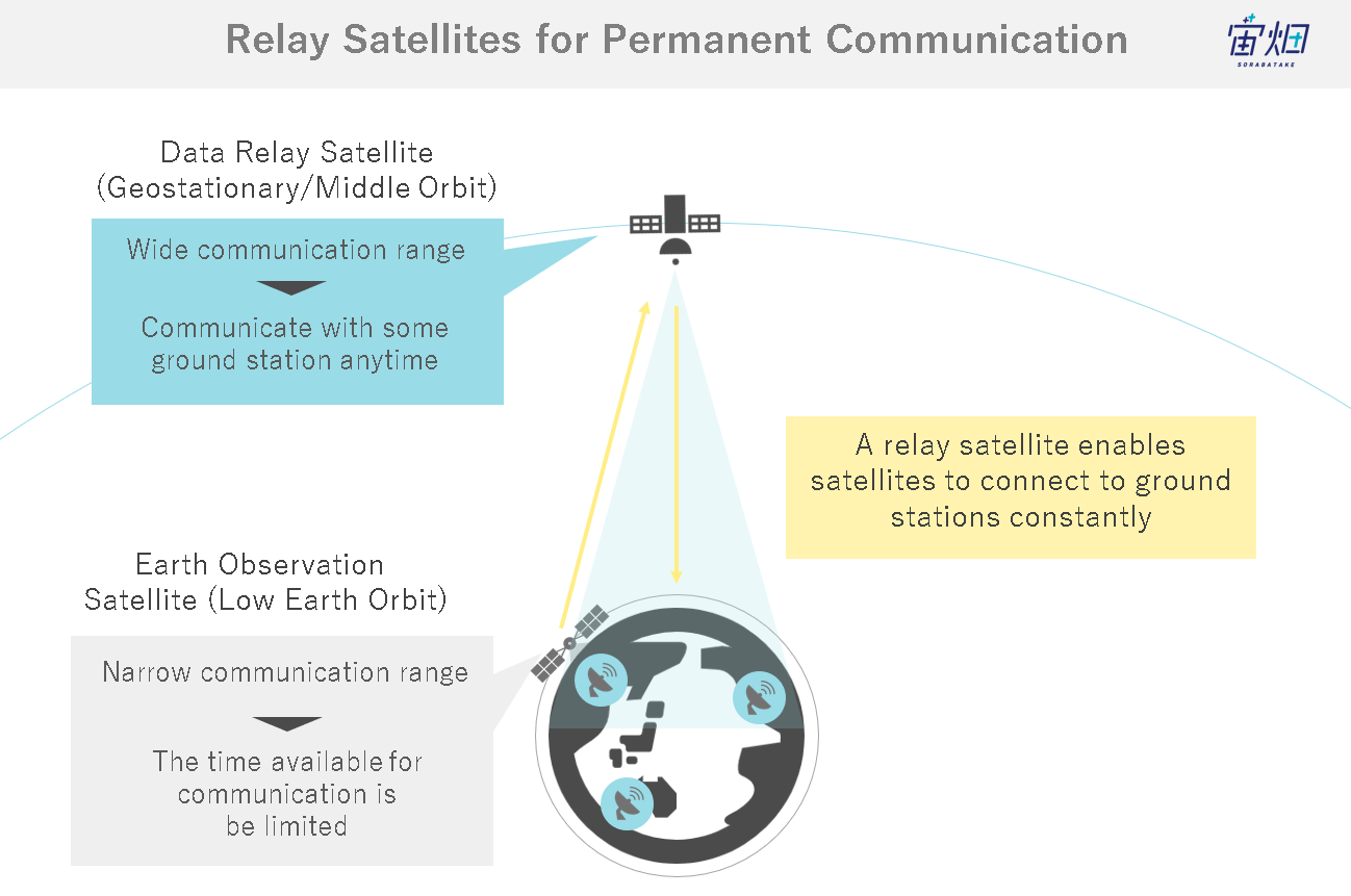
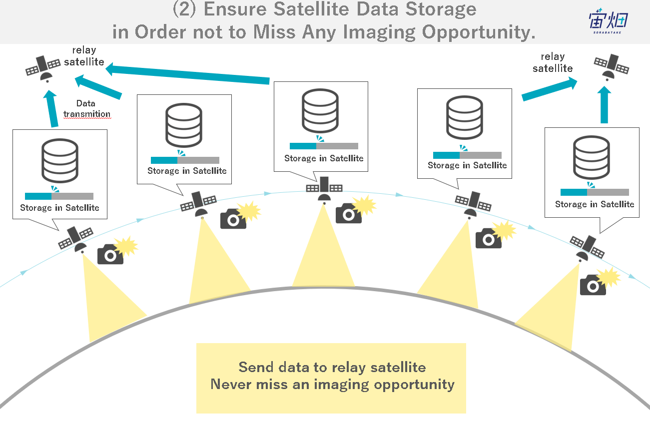
Mr. Mori:We develop WarpHub InterSat, a relay service that eliminates latency and improves the immediacy of data communications for operators of observation satellites in low Earth orbit and space stations through a medium Earth orbit relay satellite that can send and receive data using laser beams.
However, there still needs to be more real-time data unloading and a lack of train data needed to create solutions using AI and machine learning. However, there still needs to be real-time data unloading and teacher data needed to create AI and machine learning solutions.
Therefore, we would like to increase the amount of downlink data by making the communication speed fast, and at the same time, we would like to create a worldview where data can be immediately unloaded to the ground using relay satellites.
For example, when a disaster occurs, it can take several hours, or even a day or more, for a national satellite to grasp the disaster situation. Therefore, shortening that time will have practical benefits.
As for our business situation, we established an office in Washington D.C. last year and are now conducting technical studies with U.S. government agencies and private operators. We will provide our services as a pipeline to send data to observation satellite operators who use various sensors, such as hyperspectral (sensors that can observe wavelengths more finely than ordinary optical sensors) and R.F. (radio frequency) sensors, in addition to mainstream optical and SAR sensors, without dividing them.
Sorabatake:There are many needs for Warpspace to increase the speed of satellite data acquisition, but what kind of satellite providers do you receive inquiries from?
Mr. Mori:There are many satellite providers, including optical, SAR, hyperspectral, and, recently, meteorological systems. Our strength lies in the fact that we can make the communication speed about ten times faster than the existing radio communication speed. In terms of immediacy, SAR satellites, in particular, have a large data volume, so even when we need to send data immediately, it is difficult to find something that can be done using existing radio waves. At such times, those who find our service will want to try it. As for end users, there are many national and government agencies, although security is also included.
Sorabatake:Thank you very much. Now I would like to move on to the theme of the dialogue.
(3) Challenges in Satellite Data Utilization
Challenges in Japan's Lack of Progress in Satellite Data Utilization
Sorabatake:Do you feel that satellite data utilization is progressing worldwide and in Japan?
Mr. Kanemoto:Satellite data use is increasing worldwide. For example, we have partnered with an Italian company to provide analysis using a technology called interferometric SAR, which looks at building displacement on a millimeter-by-millimeter scale. More and more clients are using this technology, and they have confirmed that the results they get from ground surveying are almost identical to those from satellite analysis. The availability of satellite data has led many companies to replace their ground measurements with satellite data and continue to use it.
Sorabatake:Is the realization that satellite data use is expanding primarily due to improvements in analysis technology?
Mr. Kanemoto:Actually, the same level of accuracy as now has been available for more than ten years, and its use was expanding overseas. However, in Japan, many companies are precedent-driven, and it is difficult to change the precedent of “we always order from here, so let us order from here again,” so I think it is difficult for new technologies to be introduced.
When we proposed PoCs for satellite data, they were rejected, saying they might consider again “after the frequency of acquisition is increased” or “after the resolution is increased.”It has been difficult to introduce new technology.
We have talked about the need to improve the capabilities of satellites and increase the number of satellites in the future and have explained the need to prepare a system now, but the field is reluctant to pay for something that is not useful now, so we feel that this is not going to work well for research and survey applications.
However, infrastructure providers such as electric power companies must gradually consider profitability due to the current energy situation. In the past two years, people who tried using satellite data in the past, which ended with not-so-great results at the time, began to say, “I tried using satellite data today, and it works surprisingly well.”
Lack of Awareness of Satellite Data Use
Sorabatake:Do you feel a growing need for satellite data as a trend?
Mr. Kanemoto:Yes, I do. There are many space-related topics, such as space travel, the Artemis project, and lunar exploration, and the government is also supporting them, so needs are growing. However, it is also true that the demonstration tests and other experiments have yet to produce concrete results that would move the industry and many businesses. Therefore, getting more and more exposure in newspapers and the media from companies that have started to see results and get users interested is essential.
Sorabatake:We have to disseminate information more.
Mr. Mori:People who usually have their antennae up for space-related information are sensitive to trends, but people who do not look at them do not notice them.
Mr. Kanemoto:Many events are being held, but these are still conducted by people in the space industry and for people in the space industry. We should consider how much we should increase the number of events for people outside the space industry.
Mr. Mori:There are various consortiums, but 70 to 80% of the members are space industry people, so if we want to expand our activities, we need to gather more non-space people. To that end, we must invite non-space companies and organizations to join us.
From Security to the Private Sector
Sorabatake:Mr. Mori mentioned that many end users are national and government agencies.
Mr. Kanemoto:Thanks to the needs of government agencies, many satellites have been launched, and the number of satellite data applications is increasing, so we would like to increase the number of private-sector users as well.
Mr. Mori:Yes, that is right. We can be good drivers. Just as when the space shuttle and the ISS were built, the technology was transferred to the semiconductor and automobile industries, so with space, it is hoped that new examples of private-sector applications will be created as the public sector comes up with technology, mainly in the area of software, that has not been available in the private sector.
Sorabatake:What hurdles do you see that need to be overcome in order to expand into the private sector?
Mr. Mori:The needs of the national government and public agencies are characterized by the fact that they want satellite data as it is. Many people involved in security are also skilled in accessing satellite data so that they can perform the analysis themselves. On the other hand, the problem is that only some people can analyze the data, even if we give it to private operators as it is.
Insufficient Number of Satellites, Ground Stations, and Data Volume
Sorabatake:Are the number of satellites and the volume of data sufficient to provide the solutions customers want?
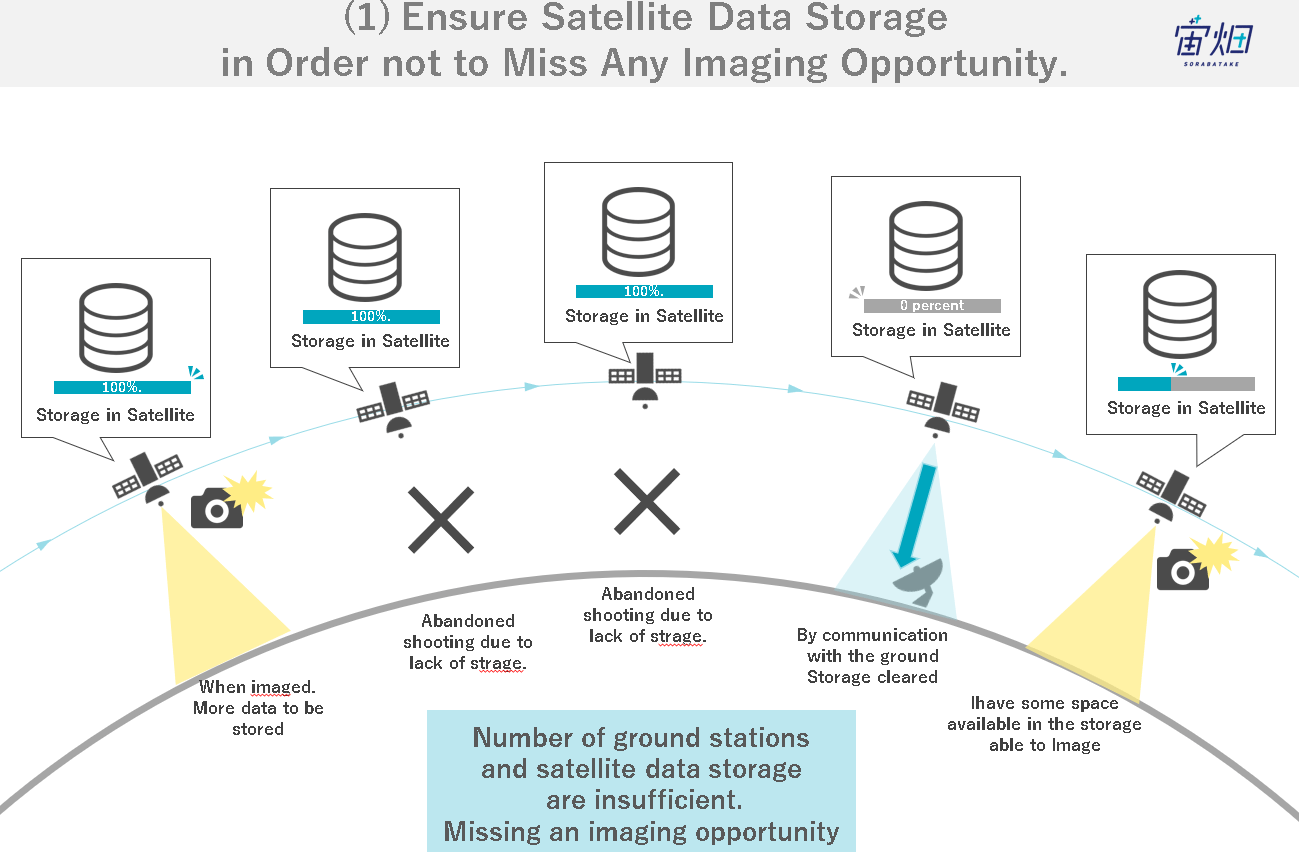
Mr. Fukuda:Satellite data must be unloaded immediately after imaging. If we can do that, we will have the opportunity to take the following image. To cope with this, we need to increase the number and location of ground stations and communications between satellites. I think keeping the capacity open when we want to shoot is crucial.
Sorabatake Memo: What is a ground station?
A ground system that sends commands to satellites and space stations in orbit to obtain mission data.
https://sorabatake.jp/16323/
Sorabatake:Warpspace has formed a business alliance with Leafspace regarding ground stations.
The two companies will collaborate on ground infrastructure services for the company’s optical communication network [Space Business News].
https://sorabatake.jp/27297/
Mr. Mori:Yes, Leafspace is a GSaaS company, and we formed a business alliance last June.
Sorabatake Memo: What is GSaaS (Ground Station as a Service)?GSaaS is a business that provides a ground station network as a sharing service.
Mr. Kanemoto:KSAT (Kongsberg Satellite Services) now has many ground station antennas. We have as many antennas as possible, so increasing communication volume further will take work.
Even with our micro SAR constellation, there are times when tasking (image requests) are rejected. In this sense, more than the number of satellites and the orbits they fly is required.
Individual Differences in Data among Satellites are Also an Issue
Mr. Kanemoto:Another issue is the difference in output data among individual satellites.
Mr. Fukuda:Yes, that is true. We are also discussing establishing a mass production system when increasing the number of satellites. A mass production system for manufacturing is fundamental, and we need to do it as if we were making automobiles from the supply chain. If we can not do that, we will end up with products that have significant individual differences. We are assembling products only with human power, which creates such a problem.
(4) Breakthroughs in Satellite Data in Various Industries
Agriculture x Satellite Data
Sorabatake:What initiatives are needed to expand the use of satellite data in agriculture?
Mr. Kanemoto:We are utilizing satellite data related to agriculture to collaborate with the marketing and advertising industry. Specifically, we are working with advertising agencies to predict the timing of commercials based on the harvest status of crops. For example, if many TV commercials for clay pot meat stock are aired when the price of cabbage is low, not only will the product sell well, but more cabbage will be sold, giving back to the farmers and reducing food loss.
Supply-Demand Linkage Business through Sophisticated Advertising by Utilizing Satellite Data
For advertising agencies, it is also a great way to appeal to customers and attract attention within the company, saying, “We are using satellite data (new technology) to market your company.” The amount of money in motion is also significant, so if satellite data contributes to changing business performance by even a few percent, it could be a business worth hundreds of billions of yen.

Since creating the same impact through pure agricultural use is time-consuming and challenging, starting by working on areas with enormous market impact is vital.
Also, by looking at the total amount of crops produced based on satellite data, we believe that if we can create a stable supply system that allows retailers to change the price of vegetables at a constant level throughout the year instead of buying them at the highly variable market price, it would be a win-win situation for both production and sales. Ultimately, we can not continue this business without overall optimization. We are working on this project from an overall perspective, in parallel with individual farmers’ data utilization.
Disaster x Satellite Data Utilization
Sorabatake:What kind of efforts are needed to expand the use of satellite data in disaster management and infrastructure industries?
Mr. Fukuda:First, there is no way to know when and where disasters will occur. The best way to be prepared for any disaster is to take pictures of the entire country, which is highly costly.
Therefore, it is necessary to take satellite data by tasking (imaging requests) with some degree of prediction of disaster locations. For example, when a typhoon occurs, it may arrive in Tokyo in two days but end up in Tochigi, so improving the accuracy of forecasting natural phenomena is essential. It is necessary to think about this with other disciplines, such as meteorology.
Infrastructure is similar to its use in disaster prevention. In the end, what satellites can see is whether any signs will occur and how much damage there will be after they occur, so it will be necessary to develop algorithms to measure such signs. To do this, we will need more data than we have now, so we will need to combine data that can be obtained not only from satellites but also from the IoT, and in some cases, we will need to compile data from entirely different data sources.
Mr. Mori:If you send a command to a satellite immediately and control its attitude, is it theoretically possible to immediately take a picture of the location you want to see?
Sorabatake Memo: What is a satellite command?A satellite command is information sent from a ground station to a satellite. Since ground station equipment is required to send commands, even if you try to send a command at the very timing of when the location you want to photograph changes suddenly, you cannot take a photo at that specific time.
Mr. Fukuda:That is right. The problem we have now is that we need to know when and where a disaster will occur. But if we can identify the location of interest in real-time, it is possible. To do so, we need to think of a way, for example, to match ground-based information with satellite data.
Sorabatake:What are the advantages of shortening the time between when a request for satellite images is made and when the data arrives in the event of a disaster?
Mr. Fukuda:When a disaster strikes, local governments think about where to concentrate rescue efforts as soon as possible. If it takes a day, it is already too late. The earlier, the better.
Currently, it may be possible to check the status of damage via SNS, but if we only rely on what is being transmitted via SNS, the information will inevitably be biased toward places where people are concentrated. For this reason, it is vital to use satellite data to get a bird’s eye view of the situation.

Mr. Kanemoto:The same problems apply to companies that manage infrastructure such as telecommunications and roads. If any part of the infrastructure is cut off due to a disaster, they cannot go to the site in the first place, so they do not know the extent of the damage. When making a disaster recovery plan, they often need to know the situation first because they can only respond later. In some cases, the location may be too far for a drone to reach, so if we can determine where the infrastructure has been cut off in a few minutes by using satellites, it will help speed up the recovery process.
Mr. Mori:So, immediacy is essential.
Markets That Can be Tapped by Improving Immediacy.
Sorabatake:What other fields can you expand into by improving immediacy?
Mr. Kanemoto:Disasters and security are the two areas that require speed.
Mr. Fukuda:Another example would be in daily life, for example, when we want to see things changing day by day, such as construction work. Monitoring the situation on the ground from a satellite every morning and evening is necessary for construction work. Currently, satellite data is just one of the materials used to make decisions in construction planning, and the practical work is done entirely differently. If the imaging frequency is increased, it will also be possible to use the data for practical purposes.
(5) Prospects
Satellite Data will Become Infrastructure
Sorabatake:What kind of future do you see for satellite data as the environment for its use improves and its utilization advances?
Mr. Kanemoto:It will eventually be incorporated into our daily lives like the Internet. People no longer need to search the Internet actively when they want to know something. We are entering a world where human behavior, as seen through satellite data, will become a source of information, and advertisements and recommendations for action guidelines will appear through AR devices based on the situation.
For example, when you leave your house to go to the station, the device may tell you that your usual route is under construction, so you should turn right, or your usual route is dangerous. If you follow the recommended route, your insurance premiums may be reduced as it results in more safe and environment-friendly driving by the insured driver. The use of satellites, which can observe a wide range of areas, will be crucial to monitor the entire world while integrating IoT and personal sensor information, depending on the location.
Cyber and physical domains will merge with the metaverse and digital twin. At that time, the role of satellite data will be to update the entire real-world globe, and we will become the infrastructure for this.
Users buy data individually, but a data distribution network like music distribution will be constructed in the future. There is already a competition to see who can build the most efficient observation network.
Sorabatake:So you are saying that it is necessary to increase the visible area using satellite data and information from other sensors.
Mr. Mori:The other important thing is setting milestones for achieving this. If we have to send data acquired by not only optical but also SAR and other sensors to the ground once a day with a resolution of 1 m, and if we have to send data on the scale of the entire land mass of the Earth, even with satellite relays using optical communications, the communication capacity will not be sufficient.
Mr. Mori:We also need to think about where to increase the resolution and where to take data more frequently. Satellite providers and analysis companies need to work together, and if data suddenly increases and there is too much data, the analysis companies and ground stations will be troubled. It is crucial to keep a good balance.
Mr. Kanemoto:Yes, that is right. For this purpose, knowing how many people would be happy to use satellite data, thus grasping user demand, is essential.
Mr. Mori:Customers want to know not so much about the satellite data itself but whether there is any profit in using the satellite data and how the profit margin will change, so we need to create suitable applications for that purpose.
Mr. Fukuda:That is right, and we also aim for that. Customers do not care whether it is satellite data or not. What they want to know is whether it solves their problems. I do not think that the current business approach of “just make data and sell it” will no longer work. Educating users on how to use satellite data is essential, but it is also important to make it more convenient and easy to use.
Mr. Kanemoto:Does Synspective also plan to fuse and analyze ground data?
Mr. Fukuda:Yes, we do. However, the reliability of the data is also essential. For example, retailers measured the body temperature of people entering a store as a measure against COVID-19, and there is a common understanding that it is safe to use a sensor if the temperature is between 35 and 36 degrees Celsius. This is because we trust the data based on our experience that body temperatures of any given degree are average.
If customers believe in the data, we will combine ground data and satellite data, and if satellite data is sufficient, there is no need to use ground data. It is more important to promote awareness and understanding that the data is often used than the quality of the data. Otherwise, it will be closed to security applications.
Mr. Kanemoto:The change we are sensing is that data reliability is becoming more widespread. Users can now verify the satellite data and terrestrial results by themselves.
Mr. Mori:We have passed the dawn of the satellite data market and are now in the growth phase, so there are many players, and they will be selected according to customer needs.
New Monetization of Satellite Data
Sorabatake:How do you see the distribution and monetization of satellite data in the future?
Mr. Kanemoto:It will be like iTunes. There will be a platform, and the satellite will be the artist, and individuals and companies can use satellite data whenever they want. There are already several platforms, but it might be GAFA, SpaceX, a completely new company, or somewhere else. We will be part of the platform in terms of the software that does the analysis and processing, and it will be similar in structure to the current video subscription.
The Internet was similar to today’s satellite data industry from 2001 to 2003. With the advent of broadband, always-on connections, and the introduction of smartphones, the Internet spread rapidly. It is difficult to imagine the existence of smartphones at that point, just as it is difficult to imagine what the killer application for satellite use is now, but I think there may be a hint in the development of the Internet industry.
Mr. Mori:As for the data business, becoming SaaS may be the final form.
Mr. Kanemoto:To get there, we need to fill in the gap between what can be done with our current technology and what still needs to be improved. As an infrastructure, we need to connect multiple satellites and be able to handle data in real time, so we may also need a space data center.
Sorabatake:What kind of satellite data licensing do you expect to see in the future?
Mr. Mori:Nowadays, even if you purchase satellite data, it is difficult to use it for purposes other than those for which it was initially applied. The terms of use are bound in detail in the contract, such as prohibiting use for purposes other than those for which it was initially applied or prohibiting provision to customers without a certain degree of processing. The license will disappear, similar to the application.
How Japan Can Win in the Global Satellite Data Market
Sorabatake:What will it take for Japan to win in the global market?
Mr. Kanemoto:When I go around overseas, all I hear about is security, and when I talk about how we are using satellite data to monitor the growth of crops and collaborate with the advertising industry, people ask me to tell them how we are doing it. In that sense, Japan is at the forefront of uncovering needs.
Overseas satellite providers are beginning to think about SPAC listing (i.e., not owning their own business, but aiming to acquire unlisted companies after listing) and business strategies beyond IPO, so I think there is an excellent possibility that Japan can lead in creating examples and applications for this purpose. Right now, it is good to accumulate usage know-how and provide technology tied to the know-how.
Also, in Japan, I would like to see each company collaborate and work together, including the government as well, and form a “Japanese Union”. We cannot match the capabilities of foreign countries in terms of satellite capabilities and analysis processing, but if we can provide consistent solutions that combine individual applications, that would be an advantage.
Mr. Mori:In Japan, there is also the Consortium for Satellite Earth Observation (CONSEO) (the most extensive satellite earth observation community in Japan, where players from industry, academia, and government gather to compile recommendations through discussions on overall strategies and policies for satellite earth observation in Japan). The Ministry of Economy, Trade and Industry (METI) also tries to spread overseas examples in Japan. Things will change significantly this year with those factors in place.
Sorabatake:”Japanese Union” is a courageous word. I hope that Sorabatake can also contribute to information dissemination. Thank you very much for your time today.
(6) Conclusion (Comments from Sorabatake)
This interview taught us about the challenges of satellite data utilization and breakthrough cases and prospects.
Those in the satellite data industry can conceptualize the ultimate goal of realizing “a world where satellite data is used as a matter of course in everyday life, just like the Internet.”
As more satellites are launched in the future, it is hoped that the combination of inter-satellite and
ground data and the enhancement of the immediacy of data communication will make the data more convenient and more accessible for users to use.
We will continue to watch the three companies promoting their business at the world’s cutting edge as companies from Japan.
