Where can we observe shooting stars? Find your nearest stargazing spot using satellite data!
Have you seen shooting stars before? According to the survey carried out by Sorabatake, 20% of answerers responded that they have been wanting to, but never have seen shooting stars before. If that is the case, we will introduce you how to search for stargazing spot using satellite data.
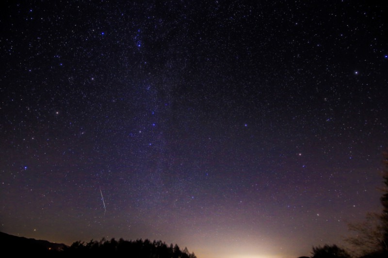
According to the survey carried out by Sorabatake using twitter, 18% of the followers which answered the survey said that they “have been wanting to, but never have seen” shooting stars before.
Well then, let’s go see shooting stars!
We considered whether using “satellite data” is effective for finding places suitable for watching shooting stars around the reader’s living.
We will show the result in this article.
※This is 9th article of “Space Data Utilization”, a project which Sorabatake members seek for interesting people/objects/events through satellite images, updated irregularly.
We are still in the middle of studying and training, but we hope you will enjoy our reports. Casual advices are always welcome!
(1) The result of searching stargazing spot using data of nocturnal light
In verifying this project, we found out that satellite data is useful to find places which are somewhat suitable for observing shooting stars; dim spots.
In searching for dim spots, what we focus in satellite data is “nocturnal light”.
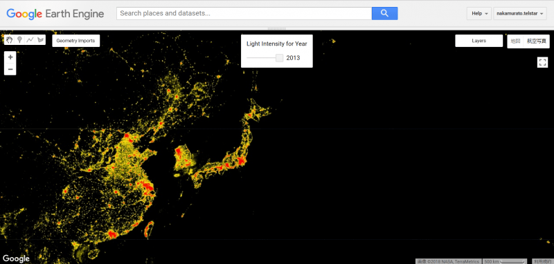
We can see that city center is identified in red.
Comparing with data from 1992, the difference between areas identified in red shows how much China has developed in this 20 years. Credit : google earth
Nocturnal light is, as it can be presumed from the word, a vocabulary which shows the lights in the Earth filmed by satellite during the night time.
Those are lights of houses, street lamps, and many other things.
As it can be seen from the photo, city center is identified in “red = bright”.
By examining nocturnal light, it is possible to distinguish if the place is light or dark.
From this, we can easily predict if the place is suitable for observing stars.
Incidentally, there are cases in which nocturnal light is used to analyze development of various countries, or to predict the GDP of the year.
(2) How to find stargazing spot using "Google Earth Engine"
Well then, how should we find stargazing spots?
This time, what we use to find is “Google Earth Engine”, which we already introduced in the article “Satellite image analysis changes? What is so hot about Google Earth Engine”.
We will show the way to find it below. Please challenge if you are interested!
What we used this time is this script.
https://code.earthengine.google.com/110b7f8e2650740b71b8068a0de99887
Anyone who has a google account can use it without any cost. I recommend you trying it while reading this article.
※For those reading this article using smartphones, please try it from PC when you have time.
STEP 1: Search for place where shooting star was found
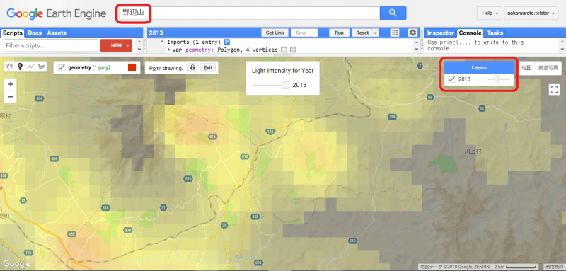
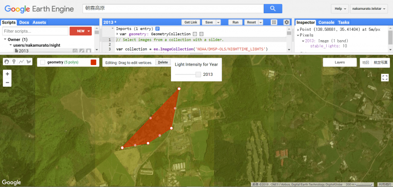
First, we will search for the circle just around the “Nobeyama Cosmic Radio Observatory”, a place where the author first observed the shooting star, in the “Google Earth Engine”.
Let’s recall your memories and search for the places which you think the starry skies were beautiful.
After searching it, press “Layer” which is displayed in right top of the screen.
Slide the bar to the left and the map will appear under the nocturnal light data.
Verify if the search result seems likely.
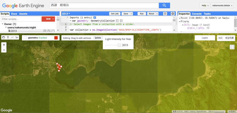
Step 2: Enclose the area which you found the shooting stars
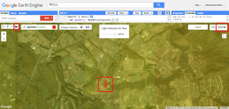
Next, select the aerial photograph using the tab in the right top of the screen.
Press the part enclosed in red frame in the left top of the screen, and enclose the area where you observed the starry sky.
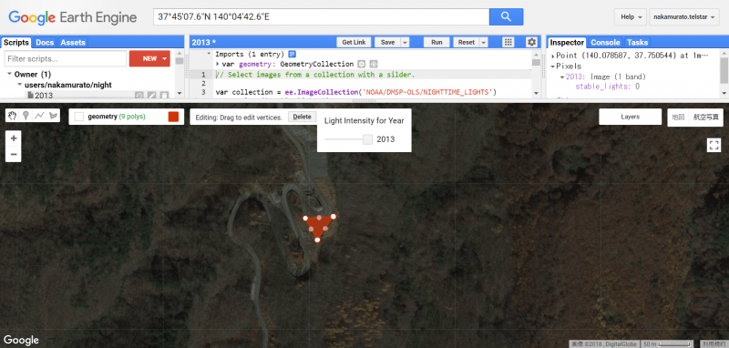
Step 3: Check the level of the brightness of the area which you found the shooting star
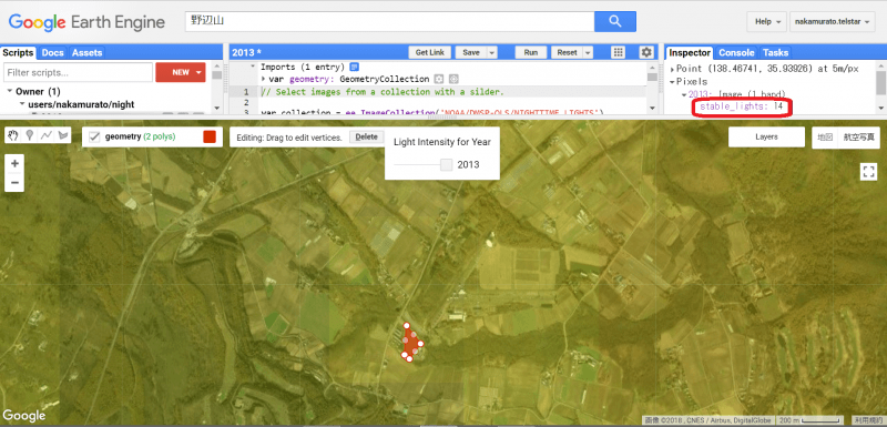
“Google Earth Engine” tells you the brightness level of the nocturnal light of the area selected.
Double click the selected area and a new item “stable_lights” appears in the right top.
The number “14” displayed aside denotes the brightness level.
We found out that the brightness can be divided into 0 to 63 levels in this research method, and that it gets dimmer as the level gets closer to 0.
The place with brightness level under 14 can be predicted that it is dimmer than the place where the writer saw the shooting stars.
This means, we can predict that places with brightness level under 14 might be suitable for observing shooting stars.
Step 4: Check the level of the stargazing spot which attracts your interest
Let’s check the brightness level of other spots, and examine if the rate of brightness level “under 14” is reliable as a measure for finding suitable place for shooting star observation.
This time, we got some shooting star photos from @Starryheavens_p, the operator of “days of camera and seikei photo”, and asked where the photo was taken.
Let’s check the brightness level of the shooting location!
■Saiko, Nennbahama
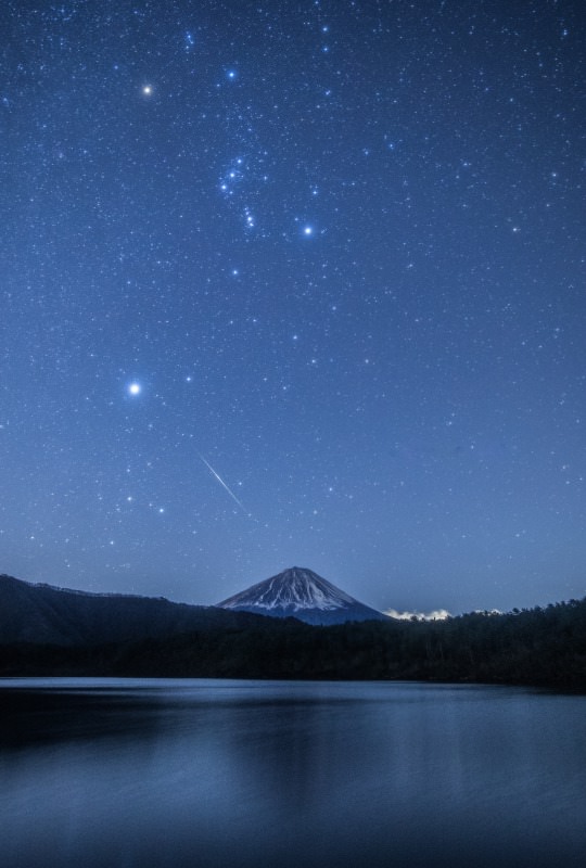
This is a “seikei” picture of Saiko, Nennbahama.Constellation Orion can be seen clearly.
Let’s check the brightness level of this place.
The brightness level of this place was 10. Since it is 4 levels below the brightness level of the Nobeyama(level 14), it can be said that this place is dimmer than Nobeyama.
■Asagiri Plateau
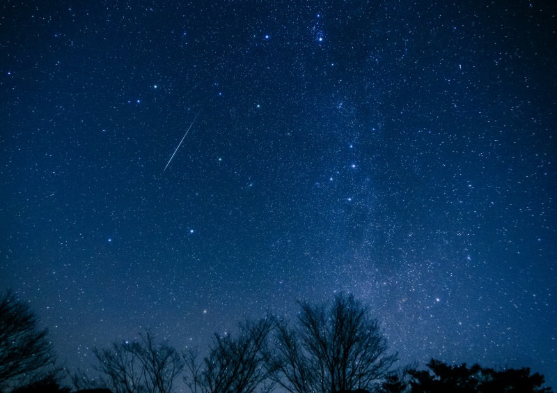
This is a picture of Asagiri Plateau, located in the South west of Saiko(the picture above). This picture too, shows the shooting star clearly.
Let’s check the brightness level of this place.
The brightness level of this place was also 10. This shows that the brightness level “under 10” can be a guideline in finding spots suitable for observing shooting stars.
■Urabandai, Fukushima prefecture
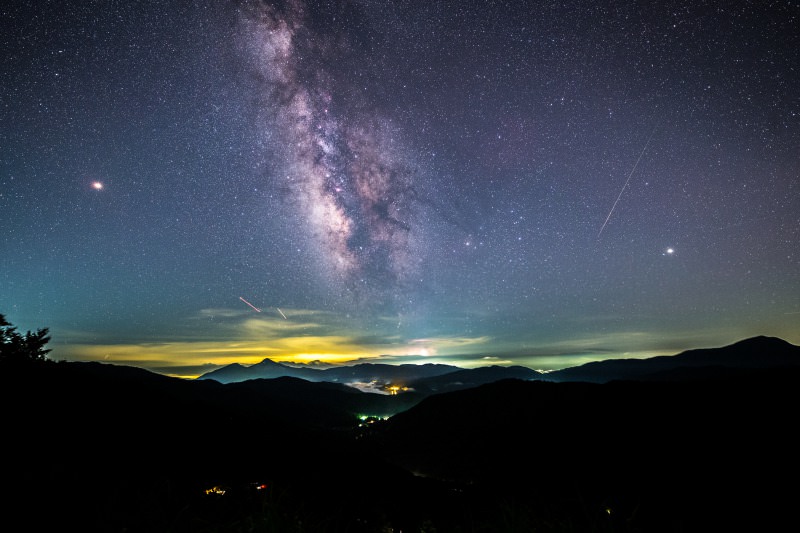
Last but no least, the Milky Way photo taken from Urabandai, Fukushima prefecture.
What a beautiful picture!
The brightness level of this place was…
Zero! There seems to be a stopover in mountain path which we can stop by to take photos.
It will definately be lovely to see the starry sky from this spot with our own eyes.
Finally, we could conclude that places that sensed brightness level “under 10” seems to be the spot with starry skies suitable for both shooting star observation and “seikei” photographing.
(3) Remaining tasks
Throughout this article, we had explained a simple but effective way to search for places suitable for shooting star observations.
However, there still are some remaining topics which must be cleared.
■Low sensitivity of nocturnal light data
City centers such as Tokyo or Osaka are too bright, and, as those who actually touched the “Google Earth Engine” might have realized, the level of the brightness does not change in Tokyo or Osaka from the maximum level “63”, wherever selected.
However, that’s not actually precise.
I have seen Geminid meteor shower in the Tokyo.
Therefore, we could say that it is not always impossible to see shooting stars in the places with brightness level above 15.
The reason why this problem occurred can be assumed that it is due to low sensitivity of satellite data.
If the sensitivity of satellite data is raised in the near future, then there might be further divisions of the brightness level in smaller scales of the map, with more accurate classification.
■Difficulty of judging the accessibility of the spot
As you can see from the data, spots with brightness level “0” are very dark.
Therefore, we cannot judge the possibility to access or park just by watching the Google Earth Engine.
We can make it easier to find spots suitable for both accessing and stargazing by matching the result we got from Google Earth Engine with the terrestrial data.
(4) Future perspective
This time, we focused on using “nocturnal light data” to find places that are able to observe shooting stars.
If the sensitivity of satellite data is raised, it might be possible to find correlation between the “observable magnitude” and the “brightness level”.
Furthermore, it might enable to define the numbers of constellations capable of observing from the spot.
In addition, if it is combined with terrestrial data, it might be possible to find if it is safely accessible.
Furthermore, it might enable to verify whether there are nothing that interrupts any stars.
Please try using “nocturnal light data” in searching for stargazing spot.
