We are proud of our services because we have been able to do "this" The road to social implementation – Skymatics, a company that solves many industrial problems from the sky.
Skymatics solves all industrial problems by remote sensing and its own analysis technology. This interview is a must-read for those who are familiar with "social implementation with advanced technologies". The keywords are "persistence", "price setting", and "discernment of issues".
This article is the first part of an interview with Skymatics, a company that solves industrial problems from the sky with its strengths in image analysis and GIS technologies. They are also listed in the January 2021 issue of Forbes Japan’s Startup Directory. The second part can be read here ※ Released on Friday January 22nd, 2021.
– I embarked on a start-up to provide services but I wasn’t confident enough so the business faded out
– -I want to provide as much cutting-edge technology as possible to my client but the response has not been good.
If you are in business and have these problems, please read through this article and reflect on your current business situation. We believe you will be able to grasp opportunities to grow your business. We believe you will be able to grasp an opportunity of growing your business.
This article was created after having listened to Zentaro Watanabe – CEO of Skymatics as well as Yasutaka Kuramoto – CTO of the company.
Who we met this time?
I majored in hydraulic engineering. After joining the space business domain at Mitsubishi Corporation in 2002, I was involved in the launch of new businesses such as satellite imagery sales, M&A of subsidiaries, and GIS and location information services. In October 2016, I established Skymatics, Inc. as a joint venture with investments from Mitsubishi Corporation and Hitachi, Ltd. and assumed the position of Representative Director. In October 2019, I executed a Management Buyout (MBO) with management and a Capital Increase Through Third-Party Allocation.
I was involved in the studies of remote sensing while at university. After joining Hitachi, Ltd., I participated in a project to develop a ground station for satellites and designed and manufactured a simulator to analyze satellite behavior. He then was assumed to be the CTO of Skymatics from November 2016.
This article is divided into two parts: the first part describes the efforts made from business demonstration to social implementation, while the second part summarizes the future prospects and expectations of the remote sensing industry.
To summarise the first part the keywords are “persistence”, “price setting”, and “discernment of issues” to democratize cutting-edge technologies.
What is it about Skymatics that can solve various industrial issues with remote sensing and imagery analysis?
In recent years, the use of drones has really increased.
The Ministry of Economy, Trade, and Industry (METI) has released the “Roadmap 2020 for the Industrial Revolution in the Sky,” and there is a wide range of industries that utilize this technology, including logistics, security, medical care, disaster response, infrastructure maintenance and management, surveying, agriculture, forestry, and fisheries.
Skymatics also provide services that solve various industrial issues, using drones or other remote sensing technology.
First, we asked both Mr. Watanabe and Mr. Kuramoto about their career history.
Sorabatake:Mr. Watanabe, Mr. Kuramoto, please briefly tell us about your career?
Watanabe:I always thought I would start a business in the future when I was studying at university. However, as I had only studied engineering including mechanical and fluid engineering, I decided to join a trading company in order to learn about business.
After I joined, I was posted to the space division and was involved in the areas of satellite imagery, and location information service. In the space industry, I sold satellite data from the GeoEye, WorldView, COSMO-SkyMed, and SkySat satellites, and provided related services.
Kuramoto:I studied so-called remote sensing, such as satellite imagery analysis at graduate school. I wanted to be involved in remote sensing even after graduating, so I decided to go to a company that was winning defense and security-related projects, and so found a job at an electronics manufacturer. Since then, I have been doing satellite-related work in the field of security. In about 2012, Mitsubishi Corporation and Hitachi teamed up on a project, and I was involved as a project manager for Hitachi and Mr. Watanabe was involved as a project manager for Mitsubishi Corporation, which is how I met Mr. Watanabe.
A vision that has been rooted in Skymatics since the company's founding: "Delivering limitless information from the sky and solving problems in all industries through remote sensing.
Sorabatake: So, you both met as business partners dealing with satellite data in the remote sensing field, and from there you decided to do Skymatics together? When and how did you come up with the idea of founding Skymatics.
Watanabe:We came up with the idea in 2014. While I was involved in the satellite imagery sales business, although I felt the space industry’s main business was selling data, there was little interest in delivering information properly, and that the “value” of analyzed information was not recognized.
More specifically, I believe that information can only be considered valuable when it satisfies these three elements: analysis, freshness, and usability. No matter how accurate the analysis information is, it is meaningless if it arrives a week after the user wants it. If it takes a very long time to get, analyze, and manipulate the information, it’s also meaningless.
For this reason, I felt that IT and GIS technologies were lacking when it comes to implementing remote sensing technology in society, so I started planning to start a company that would focus on this area.
It was also around the same time that I was exposed to DJI’s Phantom 2 drone, which was also a big trigger. I was impressed by how easy it was to acquire data, and felt that this was a technology that would change the world.
Kuramoto:Watanabe-san did mention that the only current example of satellite data that satisfies these three elements is weather forecasting. The use of fresh images and easy accessibility is a really good thing.
Watanabe:Yes, because anyone can easily have access. And the reason this system is in place is that the JMA converts images from the Himawari weather satellite into weather information, right? In the end, it is useless to have only satellites, but it is necessary to build a system to convert satellite information into information that anyone can access quickly.
The vision that emerged from these experiences is “to deliver limitless information from the sky and solve the problems of all industries through remote sensing. For six years since we had this vision in 2014, we have not wavered in any way, even one bit.
After creating this vision, I searched the world to see what kind of technology I could use to make my vision a reality. After searching around, I felt that I couldn’t work with anyone, so I decided to start my own business. After I made this decision, the first person I asked to join was Yasutaka-san. Although he is an engineer, he can talk about technology from the market’s point of view, and I thought that if we worked together, we could create a product with a real market value that could be implemented in society.
Sorabatake:An engineer who can talk about engineering from a marketing perspective is quite important, isn’t it?
How was ”IROHA” created at the time of the company's foundation? The key steps to provide for and serve farmers in 10 years time.
What is it about "IROHA" that, in 10 years' time, can solve problems facing farmers?
Sorabatake:So we heard the background story of the company foundation and the first project, a leaf color analysis service is called IROHA, isn’t it? Please summarize “IROHA”for us.
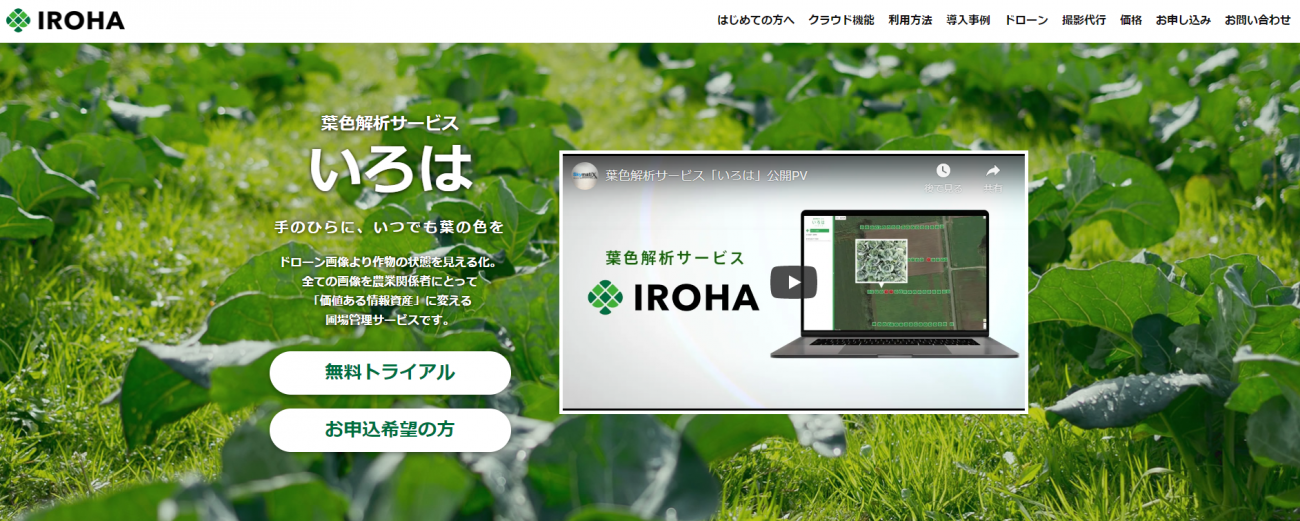
Watanabe:“IROHA” is a remote sensing service for farmers on the vision of having “the color of leaves in the palm of your hand at all times”, aiming to solve the problems farmers will face in 10 years’ time.
As farmers usually determine a variety of things from information on the color of leaves and the condition of farmland. In order to keep track of this, they need to visit the farmland frequently.
However, as the number of farmers decreases in the future, we can imagine farmland owned by a single farmer becoming larger and wider, as big as 20 km to the north and 20 km to the east. This would certainly increase the amount of time spent on the move in farming compared to the current situation.
Even today, few farmers are able to carefully look at their farmland properly, and this will become even more difficult in the future. In this way, we can expect to use remote sensings such as drones and satellite data, but leaf color depends on the time of day the drone flies and weather conditions. So, I think it will be extremely difficult for farmers to analyze this information and make good decisions.
So, with IROHA, you can upload the drone images to our website and run an analysis, and we will provide you with the results in as little as 10 seconds, depending on the content of your analysis.
Sorabatake:10 seconds is amazing. I can see the amazed faces of farmers, who used to walk around the farmland to check crops, one by one, but now all they have to do is fly a drone and give the data to IROHA.
Watanabe:The key point is that it takes as little as 10 seconds to get the analysis results that are useful to farmers, not raw data.
Agriculture can also be called a manufacturing industry as it is in the act of making and selling products, but there is one crucial difference from existing manufacturing industries. Agriculture do not have drawings. In the manufacturing industry, there are always drawings, and because of drawings, information can be integrated, and because of drawings, new ideas can be born and business improvements can be realized.
In that sense, IROHA can be called a service that provides drawings to farmers. IROHA was developed based on the concept of visualizing where to look around today and what is happening where on the drawing board when farmland becomes larger in the future.
The inspiration for "IROHA" came from a forest in Hokkaido that I saw at a hotel on a business trip.
Sorabatake:When and how did you come up with the IROHA idea?
Watanabe: In 2015. When I was on a business trip to Hokkaido, the view from my hotel room was of a forest, and the green color of the forest looked different every day, every time. At that time, I did feel that drones might be able to solve issues in the agricultural industry, and I realized the obvious fact that the same green color can be different depending on how light reflects it.
Even if a farmer takes a picture of his own farmland with a drone, he may face the challenge of being unable to make a decision because the color of the green captured in the image differs depending on the date, time, and weather conditions.
So, we thought that if we could provide a service that could guide farmers to the correct leaf color status that would help them make decisions no matter what drone was used to take pictures and under what circumstances. We could use drones to replace the work that farmers would have to check their farmland. This is the first inspiration we came up with for the idea of IROHA. This is the first inspiration we came up with the idea of IROHA.
IROHA - it's demonstration and social implementation
Keyword ① Persistence
Sorabatake:So how did you empower the services of IROHA in its early days?
Watanabe:For IROHA, we developed the service in the “Product-Out” format, so we put it out with what we developed based on the hypothesis which Kuramoto and I came up with. After that, we set up verification themes for each crop and adapted them, which was difficult at first.
When the first IROHA product was completed, we provided 40~50 drones free of charge to farmers, JAS, and municipalities, and told them “please feel free to fly them” and distributed them all over Japan. Since there are no other companies doing the same type of thing, we think people became interested in using us. We are thankful for them as they give us feedback on the results of analysis.
Sorabatake:When you were distributing the service, were farmers who actually used it mostly young? Or were they in the older generation?
Watanabe:It was distributed and used by farmers in all generations, from those in their 30’s and 40’s to those in their 60’s. This has continued to the present day, and the highest age of a farmer using IROHA is 67 years old. The average age of farmers in Japan today is 67~68 years old, so even farmers of average age are using IROHA.
Sorabatake:So was the analysis done by both of you?
Watanabe:No, at that time, we had a significant number of engineers. We decided to set out a project for each farmer, such as “verify this type of analysis for this farmer” or “verify the accuracy of this type of analysis for this farmer”, and improved it as we received feedback from each of them.
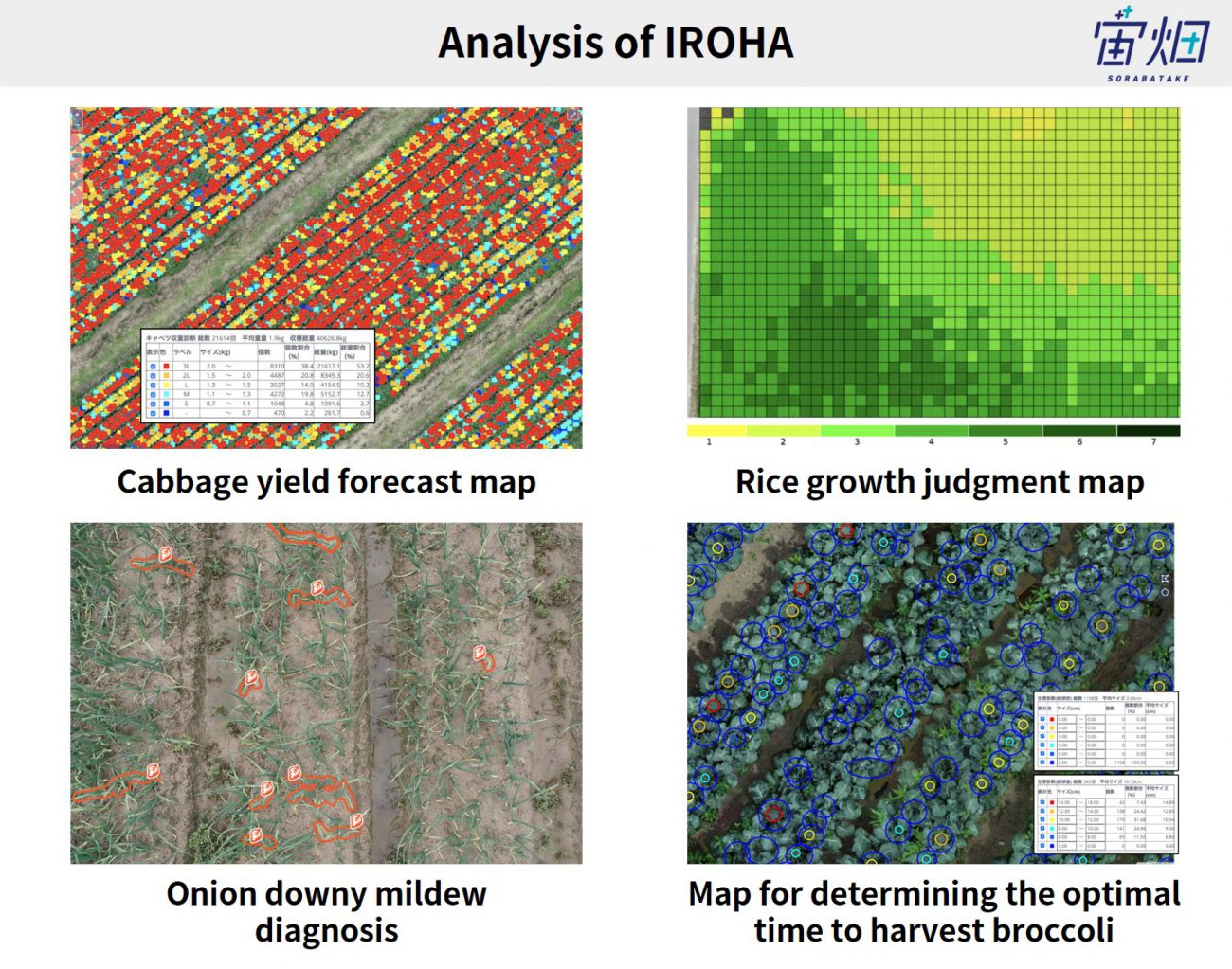
In the development of the various IROHA services, we worked so hard collecting all the data we could from the ground level. For example, in the service for cabbages, we actually counted 20,000 cabbages and we actually measured the weight of each cabbage. I In the service for paddy rice, we went around the rice fields and measured differences of rice growth with farmers.
Watanabe:I think the reason we are so confident about the IROHA service now is that we did all this work. I believe it is important to do this kind of persistent work when releasing cutting-edge technology.
Sorabatake:So for IROHA, you communicated closely with the farmers when you set out a project for each one of them. Can you tell us specifically which farmers you prioritized to talk to and what kind of verification you did?
Keyword ② Price setting
Watanabe: Yes, as you said, the initial selection of farmers is very important. However, what kind of farmers we select and how we ask them is a matter of collective know-how, so this is a bit of a trade secret.
One thing we thought was important was to ask farmers about price. We asked each of them, “So when this technology is implemented, how much would you pay for it?”
Sorabatake:You mean the price? What kind of price range is Skymatics thinking about?
Watanabe:When people see what our service provides, we think they would think the price is reasonable.
For example, we provide IROHA at 1,000 yen and RICE, a rice grading service at 500 yen. There is a reason for this.If we were only targeting large enterprises, such as large-scale farmers, or rich farmers who don’t need help, I am not sure if I would have quit a large enterprise to join. All these large enterprises are already being targeted by big business.
What they forget is to target small-scale, long-tail businesses. I believe that it is the mission of a startup; to release products in a price range that is easily affordable to people, and I believe that this is the point of differentiation from big companies.
So what we always do is to make sure that the price is affordable even for people who have the least money in the industry.
Sorabatake: I think that social implementation means to be chosen by customers, so I learned a lot from the fact that price is considered as an important point from the initial phase from that perspective, thank you.
What were the technically difficult points in the product development of IROHA?
Sorabatake:In the development of IROHA, were there any difficulties in tackling drone image analysis?
Kuramoto: It was still difficult to eliminate the difference in ambient light. This was taken into account when actually creating the product.
Sorabatake:Was it the differences in the image due to time and other environmental factors that inspired Mr. Watanabe to create IROHA.
Kuramoto: Yes, I think so.
Sorabatake:What are some of the unique features of drones?
Kuramoto: One difference from satellite data is the altitude. In the case of satellites, the altitude is constant and they orbit in a predetermined orbit. In other words, the imagery resolution that a particular satellite can take is constant because the altitude is constant.
However, in the case of a drone, it can be flown freely by the operator, so there are differences between an image taken at an altitude of 30 meters and an image taken at an altitude of 10 meters. In other words, efforts were made to increase the strength of drones to fly at constant altitudes.
Other than the above perspectives, I do not think it is that different from remote sensing using satellite data.
RICE, an app that solves so many problems, many seniors want to replace their mobile devices with smartphones!
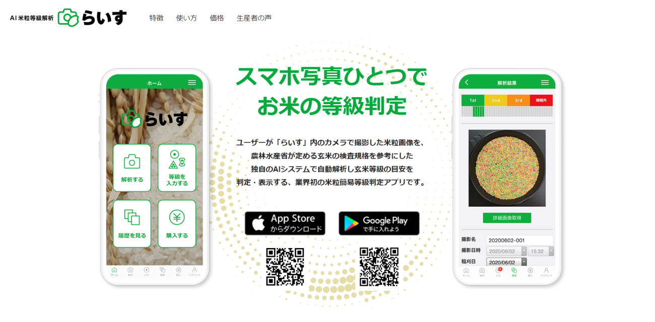
Sorabatake:What kind of service is “RICE”, the AI rice grain grading analysis service, priced at 500 yen?
Watanabe:“RICE” is quite simple. All you have to do is to take a picture of a grain of rice with your smartphone and it will determine the grade of the rice. The three features of the system are that it can be used on a farmer’s device, the grading results are available within 10 seconds after the photo is taken, and the accuracy is reasonable, so it has been used by several thousand farmers in about five months since its release at the end of July 2020.
Perhaps there is not a single remote-sensing service that thousands of farmers are paying their own money to use. In other words, I believe that RICE is the first service to democratize remote sensing.
Sorabatake:This is truly a service for long-tail and small-scale farmers with a long tail.
Watanabe: Some of the farmers are in their 70s and 80s. People of that age are using mobile devices for seniors. Our app. does not work on these senior mobile devices, and only works on an iPhone or Android smartphone device. When I tell farmers in their 70s and 80s, “Our app. only works either on iPhone or Android”, they exchange to smartphones! So, they are purchasing new devices in order to use our remote sensing services. Apps that change people’s behavior are still quite rare and our understanding is that our app must be the first at least in the remote sensing industry.
Sorabatake:What do you think were the key points that enabled you to extract such strong needs from the farmers?
Watanabe:I think it was possible because of IROHA. We have farmers all over the country who are customers of IROHA, so we get a lot of feedback on problems and ideas from them. We came up with RICE from communications with farmers.
Keyword ③ Discernment of issues
Sorabatake: I saw a video of Mr. Maruta, CEO of Houmi Co., Ltd. presenting the idea “Why don’t we show the growth of rice on our smartphone if we can now even see cabbages clearly with a drone?”
So, how did you come up with the idea of RICE with Mr. Maruta?
Watanabe: Exactly. As we had shown the world that we were using drones to identify cabbages as a case study of IROHA, we came up with the idea to “show rice grains on smartphones” with Mr. Maruta.
Sorabatake: While IROHA was a product-out type service that we first released and then updated by gathering feedbacks from farmers, it is interesting that the idea for RICE came from the farmers after the development of the IROHA service through communicating deeply with them.
I am sure farmers who use Skymatics’ services will continue to ask, “Can you offer this as a service?” If you can get a few keywords that influence what you consider important when making judgments on whether an idea would work or not, this is helpful for us to know when planning what to do using satellite data in the future.
Watanabe:The details of our judgment for the “seeds of service” that we gather are a trade secret that we cannot discuss, but we clearly have our own decision-making points that we place importance on. But we do take into consideration the details of the needs of the farmers, whether it is from a specific farmer or a common challenge across all crops.
We don’t do customized analysis or customized products for a particular farmer. We will only do services that have an impact that can change an entire industry, and we will do them when we feel that we can.
This is also the case with the cabbage yield predictions in IROHA and the rice grading in RICE. That’s because the act of predicting cabbage yields is an act that every cabbage farmer does. The act of judging grades of the rice crops is an act that every rice farmer does. When we believe that our technology can solve a problem that can be found commonly in the activities that everyone does, we will move forward.
Sorabatake:Thank you very much.
What we will talk about on "Remote Sensing Now and in the Future" in the second part of the article.
When I first approached Skymatics for an interview, I assumed someone who had worked in the space industry, focused on the potential of drones, and started a venture in drone x image analysis. However, as RICE has already solved farmers’ problems through smartphone image analysis, and thousands of people are already using it, we found out that the reality was completely different.
In Mr. Watanabe’s words, “What users want is not satellite data or drone images, but valuable information that contributes to improving operational efficiency, reducing costs, and increasing sales. Skymatics provides analysis services that meet these needs.
During the interview, he also mentioned the difference between satellite data and drones, and the potential for increased value through their combination. In the second part of the article, we will introduce the current status of remote sensing and expectations for remote sensing in the future from the perspective of two people from the space industry who have stepped into the business field using remote sensing technology.
