Can people be seen from artificial satellites? -Summary of GSD & revisit/local time satellite index-
Can we see people from satellite images? We will introduce "GSD," "revisit time," and "local time," the indexes to gain knowledge of satellite image specifications.
Perhaps the most familiar satellite for us is a meteorological satellite.
Meteorological satellites send us weather information around the world from about 35,800 km above ground level.
Did you know that more and more artificial satellites are flying below 1,000 km above ground level recently?
What can we see from satellites flying over 35 times closer to us than meteorological satellites?
Perhaps, we can even count people? When does shooting take place?
We will introduce what we can see from artificial satellites, the shooting time, and also, the performance of each major satellite.
(1) What is "GSD," the satellite vision?
Before understanding what we can see from satellites, we must understand that there are individual differences in “GSD” amongst satellites.
So a shortcut to understanding GSD from a satellite image, first of all, let’s have a try at this simple quiz.
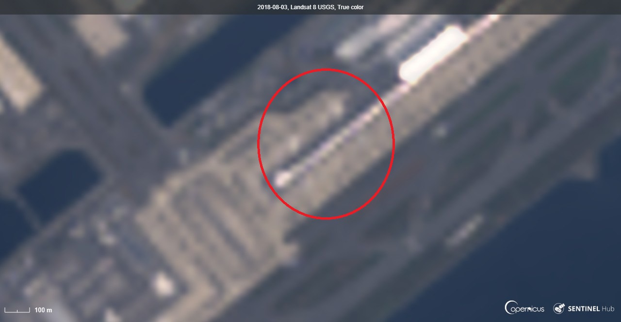
The following image is a satellite image taken from Landsat-8 orbiting 700 km above the ground. Can you tell what is in the red circle in the following image?
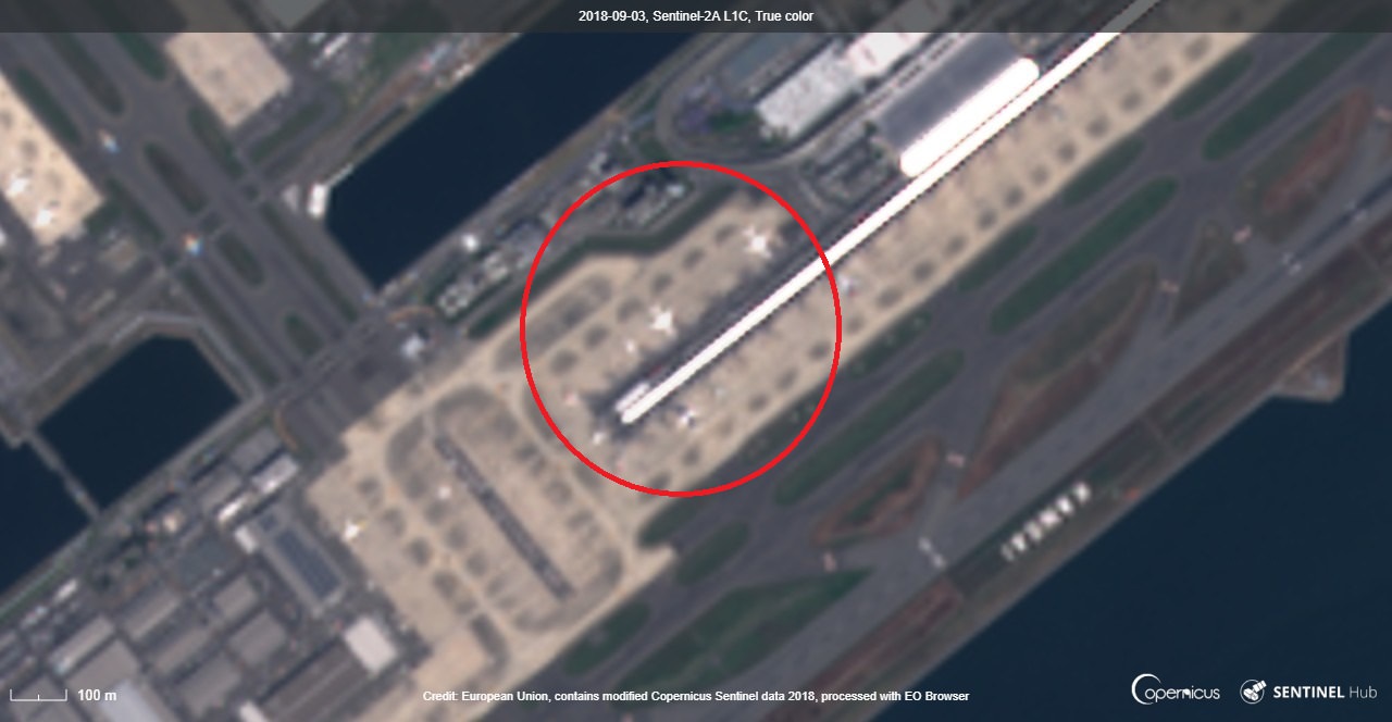
Then, here is a picture of the same place. It is a satellite image taken from Sentinel-2 flying over 786 km above ground. We can somehow, see a shape.
Here is the last picture. It is a satellite image taken from Dove, flying just over 500 km above ground. You can understand now.
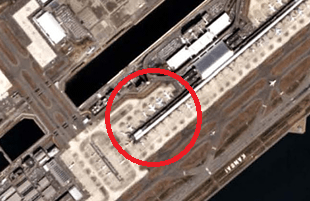
That the correct answer is an airplane.
So through this quiz, did you understand that what you see and understand depends on the satellite, even if the distance from the ground is the same?
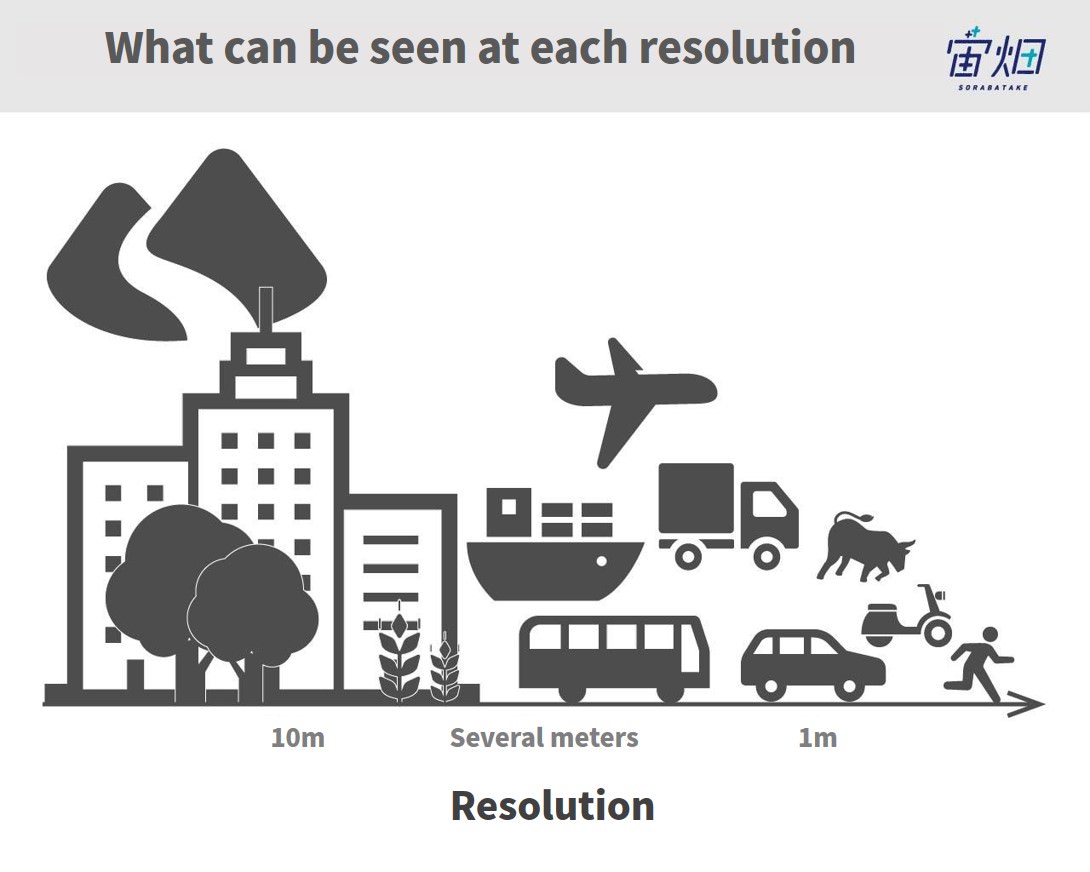
GSD (Ground Sampling Distance) is the index often used for measuring satellite performance.
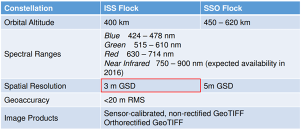
See the specification of ISS Flock (Dove) in the figure above, saying “3 m GSD.” It represents that “it shoots 3m of information on the ground with one pixel of image.”
We can also say that it can recognize an object about 3 m in size on the ground (depending on how the camera works).
Now that we have learnt about GSD, let’s check the answer to the title of this article, “Can people be seen from artificial satellites?” in the next chapter.
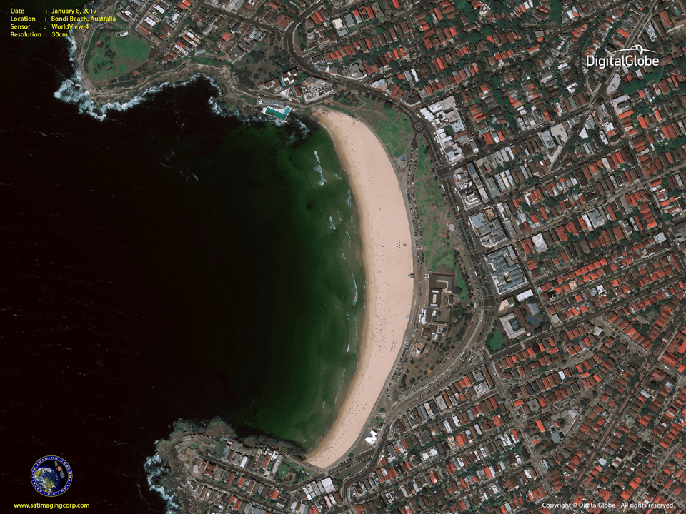
(2) People can be seen from WorldView-4, the artificial satellite with the world's highest resolution!
Already giving you the answer first, some artificial satellites orbiting around the earth now have GSD that can recognize people.
We can, somehow, see people from WorldView-4 (0.3 m GSD) that has the world’s highest resolution. The black dots in the following satellite image are people.
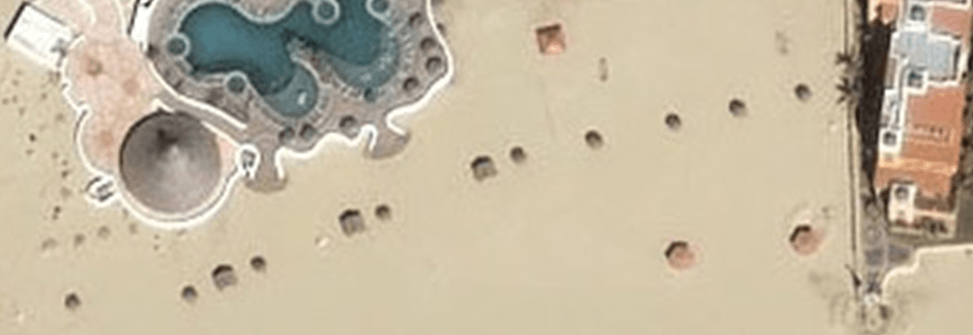
When it comes to 0.61 m GSD, as in the following satellite image, it is strange as beach umbrellas are visible, but no one is there.
Here is another quiz! How much do you think it costs to purchase images from WorldView-4 with GSD images in which people can be seen?
We introduce more information in Summary of Satellite Images/Data Price and the Future Prospects. To tell you the truth, the cost is at least 550,000 yen.
Too expensive! Unless we can find value that exceeds the purchase price, this is not a price we can afford.
The illustration above is just an example, but it is important to know and discover what can be seen by GSD. Although a detailed image is better, the better the image, the higher the price. If we could choose buying satellite GSD according to purpose, the range of satellite use expands.
The price is introduced in (6) Supplementary Note: Purchase price of each satellite image.
So then, what is the specification of satellites other than WorldView-4? We will introduce GSD and the shooting frequency/timing of major satellites in the following chapters.
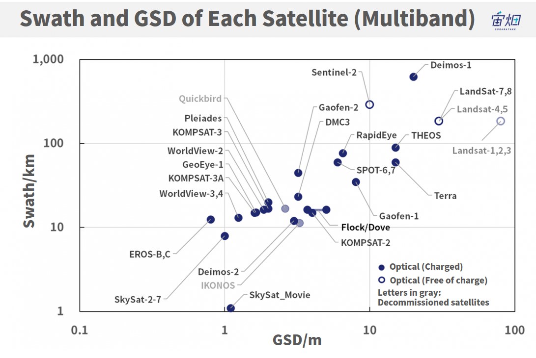
(3) GSD x swath by major satellites
First, before fully understanding GSD by satellites, let us introduce the index, “swath.”
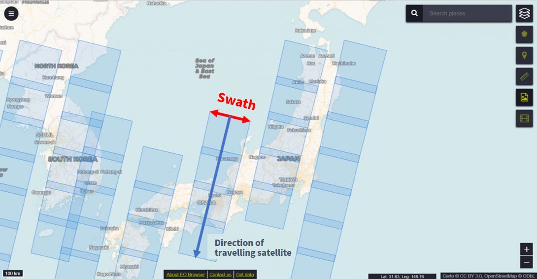
Satellites shoot while scanning vertically against the direction of travel in orbit. As shown in the graphic, the width to scan then is called “swath.”
Now that we understand the swath, the following illustrates the relationship between “GSD” and “swath” when shooting with visible lights from each satellite.
When we see the figure above, some might wonder that even something as small as 1 m could be seen from WorldView-4. Actually, there is a trick to improve the GSD.
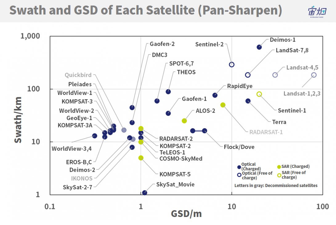
Another figure above illustrates the relation between GSD and swath. This is called a pan-sharpen image. By combining a more detailed black and white panchromatic image with a colored visible light image, a pseudo high resolution color image is created. Since a panchromatic image is black and white, it is more detailed than an image of visible light.
Compared to the first image, we can tell that the number of satellites from which we can see something finer than 1 m is on the increase.
For reference, we also added the shooting information from the SAR satellite.
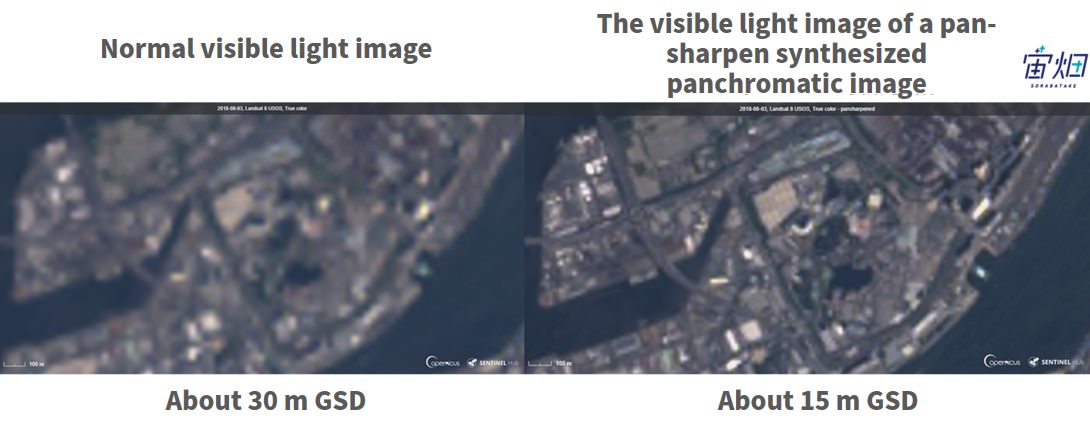
For example, by using a panchromatic image, the picture from Landsat-8 that is 30 m GSD turns into a picture with a GSD of about 15m. We can tell that the pan-sharpen image is clearer.
(4) What is "revisit time," the shooting frequency of satellites?
Next, how often can satellites shoot? The following is a summary
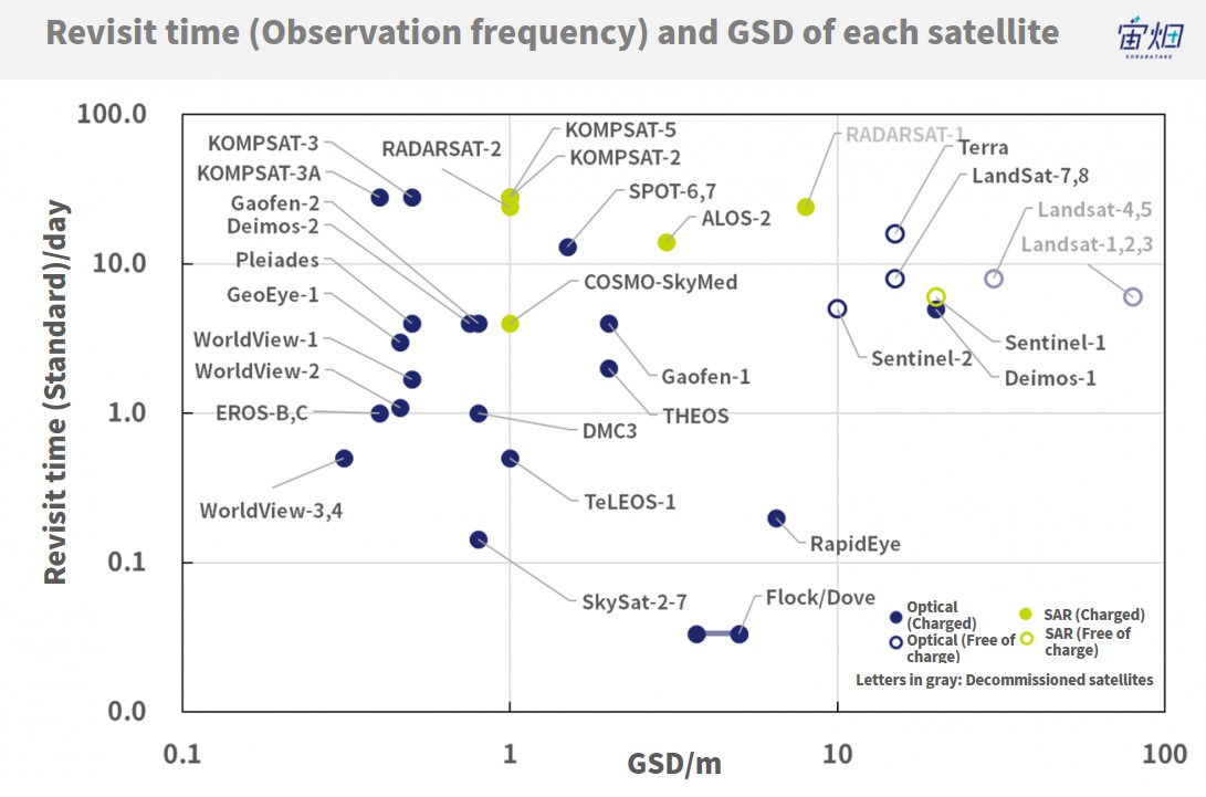
The frequency of satellites returning to the same spot is called a revisit time, written on the vertical axis.
The reason why SkySat, RapidEye, Flock/Dove have a highly short revisit time is that several satellites were launched, and the shooting frequency became very high. In particular, Planet operates 13 SkySats, 5 RapidEyes, and over 130 Flock / Doves.
It says “standard” because sometimes it is possible to shoot the same spot from an angle even if the satellite is not directly above.
However, if it shoots from too much of an angle, images may be distorted, or GSD may be poor. Such problems show that there is a limit to what any one satellite can do
(5) What is "local time," the shooting timing of satellites?
Finally, it is good to know “local time” as an index to compare satellite specifications.
The local time represents “what time period it can take images.” The following diagram summarized that.
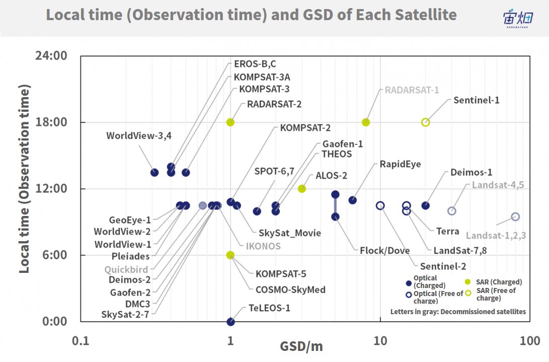
As you can see, each satellite shoots in almost the same time period (around 10:00-11:00 a.m.).
That is because water vapor is generated, and fog or mist occurs in the afternoon when the atmosphere warms up. So, it is said to be difficult to take pictures clearly from satellites.
Therefore, most satellite images are pictures of the ground around 10:00 to 11:00 a.m.
As for TeLEOS-1, since it is not in a polar orbit, it is likely to be shooting in various time periods.
(6) Supplementary Note: Purchase price of each satellite image
For this time, we will introduce an affordable image to purchase.
As we have already introduced in our previous article, there is a minimum purchase area for each satellite.
Based on this, the minimum purchase amount is summarized as follows (reference).
This time, we checked the price, assuming that purchases of images will be from archive data up to the recent past.
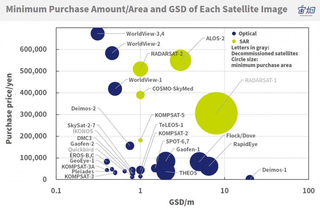
After all, we can see that the price of images with high GSD goes up.
(7) Summary and future prospects of satellite image specifications
This time, we summarized GSD and the shooting frequency/timing of each satellite.
From this article, many people may think that the information available from satellite images is still hardly not enough at present, because there are only a few satellites with high shooting frequency and GSD.
About the shooting frequency issue, as each company constructs a satellite constellation like Planet, the shooting interval is expected to become very short. It is a matter of time. As more satellites are launched, gradually, there should be a much better range in the shooting time period.
About the GSD issue, since some small satellites with a resolution of less than 1 m came out, the technical hurdle seems to have been much lowered.
Though the number of satellites with a resolution of about 0.36 m may not increase so much, many small satellites with a resolution of less than 1 m will be launched soon.
That is, over the next few years, for an object about 1 m in size in a certain place, shooting from satellites will change to be more than several times in one day. It is believed to be such a world.
The important thing is to know what kind of changes it can recognize with this level of GSD and to think about how to make use of the information from those changes.
What else can be observed from 1m GSD resolution other than what we introduced to you this time? While thinking of all the above, why not expand your ideas now to see what else is available
